
| The Cape to Cape Track (part 2) |
|
Prevelly to Conto Camp (19.5km) I had checked the weather on the internet at the backpackers and asked the locals; the concurrence was that the fronts approaching would all slip away to the south, just missing the southwest corner, leaving a fine, if overcast day. We decided to push on despite the grey sky - just as we reached the cycle path again the first drops of rain fell. They soon passed and we left the cycle path to climb up the ridge behind Prevelly via a series of tracks and firetrails. Just past the communication tower, the first of several heavy showers drove us into the shelter of the peppermints lining the track. Slightly damp, we headed on, our moods improved by the display of kangaroo paws, daisies and other small flowering herbs that had colonised the broad firetrail. |
 Firebreak through the woodland behind Prevelly |
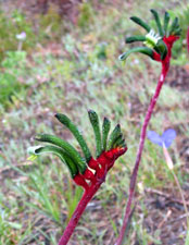 Kangaroo paws |
 |
 |
 |
 |
 |
 |
|
|
|
 View inland over Boodjidup Valley farmlands |
 View out to sea down the Boodjidup Valley |
|
|
|
|
 Boodjidup Bridge |
 Boodjidup Brook flowing through the dunes |
|
This brought us to a 2 km long stretch of soft sand beach. By now, not only had the sun returned, but the wind that blew the clouds away had strengthened to a very brisk sou-wester, whipping up whitecaps on the ocean. Heading into it on soft sand with heavy packs was not a lot of fun! The secret of walking in soft sand, though, is to follow someone else's footprints (preferable someone with the same stride as yours); so Nello, why don't you just go on a bit and I'll take your photo walking along the beach!!! |
 Into the sou-wester at Boodjidup Beach |
 The Mongolian plover - here for its annual summer vacation |
|
|
Scrambling around a couple of sets of low rocks, we finally reached Redgate, where a small plaque commemorated the sinking of the "Georgette" on the rocks just to the south in the 19th century and the dramatic rescue of crew and passengers by two locals on horseback. From the colour of the rocks it was easy to see where Redgate got its name.
|
 Sooty oystercatcher |
|
|
|
|
 The bare bones of the heath revealed by the fire |
 Looking down through the tea-trees - shades of Halkidiki |
|
|
||
|
 The cave in Bob's Hollow |
|
 View north from the ledge near Bob's Hollow |
 Contemplating the world from Bob's Hollow Cave |
|
|
|
 Limestone cliffs near Bob's Hollow |
 Looking north along the cliff line |
 Run Nello run! - rainsquall coming in from the sea |
The cliffs were certainly impressive, but our attention was more focussed on the dark shapes out to sea. A set of rain squalls was moving rapidly toward the coast and we were in the middle of a completely burnt out area with no shelter at all. So began a race along the cliff edge as we headed south, while the squalls headed east (not happy, control burners!!). We outdistanced the first two and, with luck, reached the only unburnt patch of tea-trees for a long way around just as the third squall hit the coast. |
 Conto Beach and Cape Freycinet |
 Recovering the food stash |
We set up our tent, recovered our food stash, and life was once again good. The storage fee for the food was quite cheap too; only one bag of nuts eaten by the bush rat who lived under the grass tree. That night we sat around a camp fire, exchanging stories with a pleasant couple from Tasmania, but not for long. It had been a tiring day, our longest so far, and the comfort of our sleeping bags was calling. |
 Nature smiles on the Gnoocardup forest |
|
A day off at Conto
|
|
||
 |
 Another eastern immigrant |
 |
||
 |
It was good to have a chance to sleep in and to wake to the sounds of the forest birds, even though the air was cool and the sky was grey. Our feet greatly appreciated the rest. All that was asked of them was a 4km round trip through the bush to Lakes Cave, where they were rewarded with a hamburger and milkshake for lunch at the cave teahouse. Along the way we encountered our first snake of the walk; the fair Nello almost trod on it, at which it shot into the bush at such speed we couldn't work out what species it was. The cave itself was at the bottom of a very large sinkhole (formed by the collapse of part of the cave roof) in the middle of the bush. Although not particularly large, comprising one long chamber, it had the attraction of a long pool in which the many formations were mirrored. |
 The bush near Conto Campsite |
 Looking down the sinkhole to the cave entrance |
 Hanging column and stalactites |
 A collection of limestone straws |
 Reflections in the underground lake |
|
We wandered back again for a mid-afternoon siesta as a flock of ring-necked parrots and a pair of western rosellas chirrupped and whistled amongst themselves while feeding on grass seeds near the tent. Nearby wallabies and kangaroos grazed and, in the distance, we could hear the wails of the black cockatoos and the caws of ravens. |
|
||
 |
 |
|
||
|
||||
|
||||
|
Conto Campground to Hamelin Bay (22.5 km)
|
|
|||
 |
 |
 |
 |
||
|
|||||
 Forest road beneath through the karri forest |
The road began a long and steady climb up and out of the karri grove; we passed a solo Cape to Cape walker, only our third such meeting in five days, perhaps not so surprising as most people do this walk from north to south. The flowers of the forest are more subdued then those of the heath, but in recompense the vegetation is multi-layered and there is always the hope of spotting a rare orchid. Flattening out on top of the plateau, we found ourselves walking down a corridor lined with weeping peppermint and arching peas, their branches covered with white and orange/maroon flowers, respectively. The edges of the track were scattered with pink, and occasionally yellow, orchids. |
 Pea and peppermint lined road |
 Typical karri stand in Boranup |
|
|||
 Cowslip orchids |
 Pink fairy orchids |
 |
 Dunsborough donkey orchids |
 Looking back to the karri forest in the valley |
Turning westward again and changing roads, we climbed steeply up and out of the cool shade of the karri forest into a low and more open eucalypt and peppermint woodland. The roadside here was lined with tiny paper daisies and other microflora as we crossed a grass tree hollow and headed up to a junction leading off to Boranup Trig, at 194m the highest point on our walk. It seemed unreal that the highest point on our last big walk was 4940m! Leaving our packs at the junction, we made the short detour up to the viewing platform at the trig to look out over the vast sea of green that was Boranup Forest. |
 Passing the grass tree flats |
 |
 View from the Trig over the vast green sea of the Boranup forest |
 |
 Track through the coastal mallee |
Returning, we resumed our undulating path westward and then south again. We descended slowly through the mallee-like woodland, surrounded by the low hum of a myriad of pollinating insects providing their services to the flowering plants that lined our path in the warm midday sun. Turning westward once again the descent became steeper as we followed the Boranup Beach Road once more to the sea. Halfway down, a spectacular view opened out over Hamelin Bay with its island of the same name and protecting reef. It was a good place for lunch. |
 Descending towards Boranup Beach |
|
 |
 |
||
 |
 Looking over the dense heath towards Hamelin Island |
 |
|
||
|
 Boranup Beach - six kilometres of soft deep sand |
 The ruins of the jetty at Hamelin Bay (where even the stingrays are friendly) |
I like coastal areas that have kept their charm of early days and not turned into trendy resorts with tightly packed modern "beach houses". It had been a rewarding day in the forest and even on the beach, but truth be known, if we had a choice of climbing a 1000m high spur in the Himalayas or carrying a heavy pack for several kilometres along a soft-sanded beach, we would choose the climb without hesitation. |
 Evening falls over Hamelin Island |
|
|
|
|
Hamelin Bay to Deepdene Campsite (10 km)
|
|
||
 |
 |
|
||
|
 Peppermint thickets behind the frontal dunes |
|
 Profile of White Cliff Point |
 Looking back over our path from White Cliff Point |
|
 Crossing the dunes |
|
|
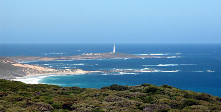
 Foul Bay Lighthouse |
 View from the lighthouse over Knobby Head |
|
 Panorama of Hamelin Island, White Cliff Point and Hamelin Bay |
 |
|
|
||
 Heath speckled with the blue fanflowers of Scaevola |
 Descending towards the reefs of Cosy Corner |
 Another friendly stumpy-tail |
|
 Limestone rock platform south of Cosy Corner |
 Crossing the rock platform |
 Curiously eroded limestone rocks |
|
||
 The beach at Cosy Corner |
 Natural rock art |
 The red rocks of Cape Hamelin |
|
||
 Cape Leeuwin beckoning across the sea |
|
||
 Limestone cliffs above Turner Brook |
 Campsite at Deepdene |
 Sunset over the Indian Ocean |
|
||
|
Deepdene to Cape Leeuwin (16.5 km)
|
|
 So what is a Pacific Gull doing on the Indian Ocean? |
 Who called the taxi? |
 Long trudge in the deep soft sand |
 |
|
|
 Deepdene rock platform |
 Jagged limestone overlaying the smooth granite bedrock |
 The last stretch of isolated beach |
 Limestone chimneys exposed in the dunes |
This led us back for one last shorter stretch of soft sand before climbing up and over the dunes to avoid a sharp cliff face - we had reached the start of the Augusta Cliffs. The path took us through low heath along the lower cliff edge, before climbing up into taller heath as we worked our way above the higher cliff-line to the south. After a short detour to take in the splendid views up and down the coast, we pushed on following a new line of track, recently slashed into the 3m high heath. |
 The northern end of the Augusta Cliffs |
 Once more the lighthouse calls |
 |
 |
 |
 |
 |
For 4-5 km we followed this, as it snaked through the heath behind the cliffs. It was a bit like walking through an endless heath tunnel, with no pleasant spots to sit and rest and only the occasional glimpses of ocean beyond the plant canopy. Perhaps this was appropriate, as we had developed a tunnel vision ourselves, focussed primarily on the ever-nearer view of the lighthouse and the end of the walk. For the only time in our 8 days out, we found ourselves wishing that this part of the track would end. |
 Cape Leeuwin across Skipy Rocks and Quarry Bay |
|
 |
 |
|
Eventually it did, breaking out onto another viewing point at the southern end of the Augusta cliffs; but it was not the view over the sea that caught our eyes, but the view behind us to the inland. Above the heath-covered hills a curious brown cloud, the colour of a smoker's lungs, was spreading towards us and the coast. As we ate our lunch, it fanned out above us and out to sea, sucking the blue colour out of the ocean and casting the world in a curious orange glow (later we found out that it was a band of smoke that had resulted from an aerial control burn in a National Park to the east). |
 Pink light over Cape Leeuwin |
|
 Smoke clouds drifting in from the east |
 The sun at 2 pm |
|
|
||
|
|
|
 Tufa cliffs formed by limestone deposited from water seeps |
 Calcified waterwheel originally used by the lighthouse keepers |
|
|
|
|
 The 39m tall lighthouse dominates the barren cape |
 Rock parrots thrive in this windy spot |
|
|
||
  |


