| Freycinet Peninsula Circuit |


About |
The Freycinet Peninsula extends out from the east coast of Tasmania and has become one of the more popular tourist destinations because of its unique geographical features. A short range of granite peaks rises sharply out of the sea to form a barrier to the southern end of the peninsula, and as a consequence, the habitats of this part have remained virtually pristine. In 1915, the region was declared a National Park to ensure that this remained the case.
|
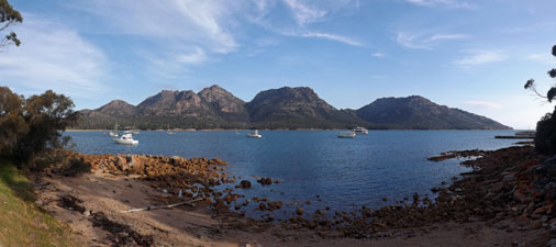
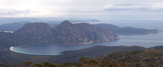
There are several walking trails within the National Park - virtually all visitors will do the short but steep walk up to a saddle in The Hazards (the granite rampart that barricades the peninsula) to take in the famous postcard view of Wineglass Bay backed by the higher peaks beyond. Many of these may descend the southern flank of the pass to walk along the white sand of the bay, fewer still might then cross the sandy isthmus that separates Wineglass Bay from Hazards Beach and complete a day circuit that loops around the western end of The Hazards. Sixteen years ago, the fair Nello and I visited here and did these walks. Today, we want to go deeper into the peninsula to experience the landscapes that lie beyond the popular tourist areas. The Freycinet Peninsula Circuit allows you to do this and, with its two nicely located camping areas, gives you time to stop and enjoy some of the more beautiful spots, rather than just walking through them. |
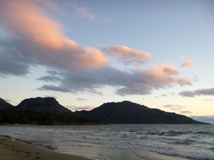 Coles Bay sunset |
Thus, on a warm and sunny morning, we left our car at a Wineglass Bay Trackhead already crowded with day-trippers, loaded our back packs and set out to explore the more isolated beaches and mountains of the Freycinet Peninsula. |
|


Hazards Trackhead to Cooks Beach (13.5 km - 90m ascent - 140m descent) |
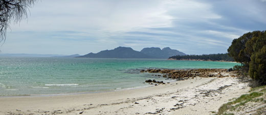
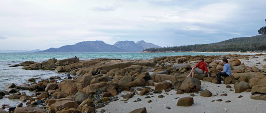
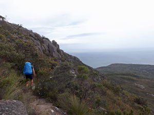
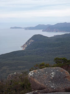
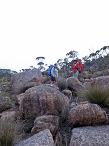
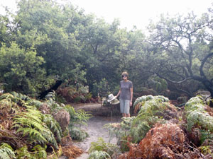
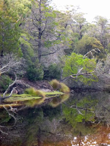
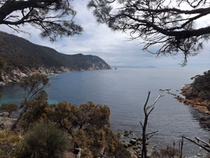
Cooks Beach is a wonderful part of the world - sitting here, pencil in hand, with my back to the dune looking over the pale turquoise water of the bay to the dark silhouette of The Hazards, I am deep in the heart of the Freycinet Peninsula. A warm northerly wind is blowing and the grey veil of cloud is steadily getting thicker. It was not always so - when we set out this morning from the trackhead on the other side of The Hazards, the sun was shining. We climbed the main tourist track that led to Wineglass Bay for a few hundred metres, before branching right to leave most of the people to continue their climb over the pass to the iconic bay. Our route would take us, not over, but around the western end of The Hazards. |
|
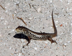
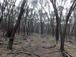
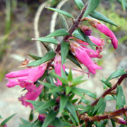
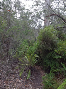
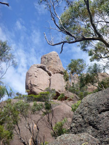
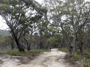
The new-looking track led us through the the coastal forest and its dense understory, breaking out every now and again to offer us views northwards over the water of Coles Bay, or inland to the pink granite slopes of Mt Mayson, westernmost peak of The Hazards. Winding its away around, across large pinkish-tan slabs of granite or on a sandy path through the tea-tree thickets where lizards basked in the morning sun, the track led us along the northern flank of Mt Mayson. |
|
|
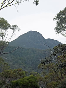
 Looking back towards Mt Amos |
 |
|
|
On the way, we met up with Jana from Switzerland, who was doing the circuit on her own. We joined forces and turned south, then east as we rounded Fleurieu Point, the western end of this rocky rampart. We were on the southern side of Mt Mayson, strolling through a monotone and mosquito-infested grove of casuarinas. I had learnt how rapacious they were last night at Coles Bay - we hurried on. |
||
 |
 |
 A dark grove of casuarinas |
|
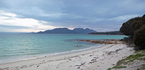
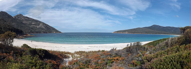
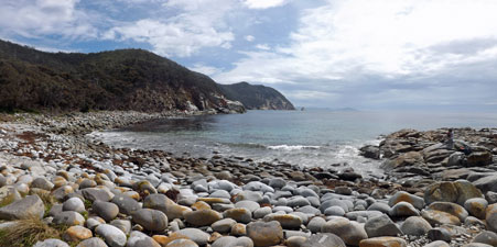
Below the track, pinkish rocks lined the clear blue water of Promise Bay - picturesque! Ahead, fringing the bay, the long pale tan sand of Hazards Beach stretched for a couple of kilometres to the south and, at its end, the steel-blue silhouette of Mt Freycinet, pinnacle of the peninsula, loomed above. With the exquisitely turquoise-tinted water lapping gently on the firm intertidal sand, the walk down the beach passed quickly and pleasantly. At its far end, we decided to stop for lunch and take in the reverse views backed this time by the silhouette of The Hazards. |
|
 Looking across Promise Bay to Mt Freycinet |
 Hazards Beach - beauty in tan in turquoise |
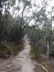
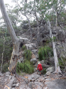
At the campground on the southern end of the beach, we turned inland to follow the track as it paralleled the coast line, rising and falling gently to cross the dry creeks running down from Mt Freycinet. The forest was also very pleasant, with the sigh of the wind in the eucalyptus and casuarina canopy and the occasional mournful call of the black cockatoo. |
||
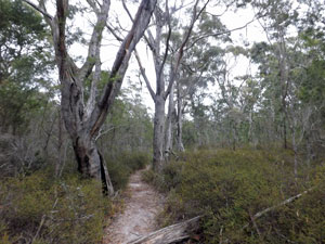 Track through the coastal forest |
 |
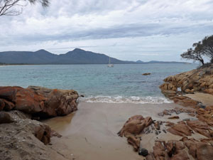
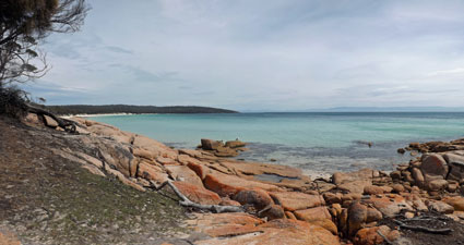 Rock platform to the north of Cooks Beach |
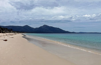
Suddenly, a glimpse of white sand appeared through the tree trunks - we has reached the northern end of Cooks Beach - looking even more beautiful than Hazards Beach. We climbed down on to its pale sand and strolled to the southern end, where the campground and water tank were. This campground has a system of volunteer camp wardens and, as we arrived, they emerged to greet us, give us the low-down on where to camp, what to do and what not to do. |
|
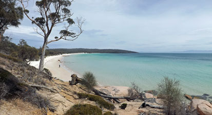 The brilliant turquoise waters of Cooks Beach |
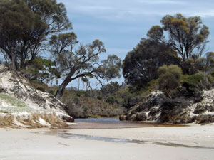 Creek flowing out onto Cooks Beach |
Tent sites are scattered along the top of a low dune amongst a grove of aging casuarinas, some well past their use-by date, meaning lots of fallen (and potentially falling) branches. This was a factor in choosing where to pitch a tent, along with the strengthening northerly wind blowing in off the sea. Sites with balcony water views were fully exposed to this, so we found a compromise, sheltered behind some coastal scrub with muted views of the bay and no overhead branches. It would prove a wise decision. As a bonus, the wind kept any mosquitoes away. |
|
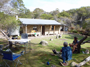 Afternoon tea at Cooks Hut |
 Evening chat on the rocks at Cooks Beach |
|
Having set up our tent, we headed up to the old restored Cooks Hut (there had been a grazing lease here early last century) to accept the camp wardens' offer of a cuppa and a chat. |
|
 |
 A portent of bad weather? |
|
Cooks Beach is popular with backpackers (it must be featured in The Lonely Planet) and there were 16 of us camped there for the night. Socialising with wardens and backpackers, soaking feet in the almost warm, clear water of the bay and musing on the splendid colours of the coastscape here brought us slowly to sunset. However, as the north wind eased, the sky became greyer. It had been good that we could enjoy this afternoon, as the weather forecast for tomorrow was not nearly as promising and, already, a few drops of rain had begun to settle out of the evening sky. |
|


Cooks Beach to Wineglass Bay (13 km - 640m ascent - 640m descent) |
It was an interesting night - around 9pm a front passed through, bringing 60 kph winds, shaking the tent even in our sheltered alcove. Other campers were less protected and there was a flurry of scuffles and flashing headlamp beams ("I think aliens have landed" whispered the fair Nello). The next morning, the tent arrangement was very different and we had acquired a couple of very close neighbours. Still, the wind did die down by then and the forecast rain seemed to be holding off. The camp wardens wandered by and told us that rain was now only expected later in the day. It prompted us to do a quick pack up and head off - we had a mountainous peninsula to cross and it would be nice to reach Wineglass Bay before the rain did. Jana was ready and waiting and the three of us set off, retracing our footsteps alongside the still lovely, but somewhat rougher waters of Cooks Beach. |
|
 One last wander up Cooks Beach |
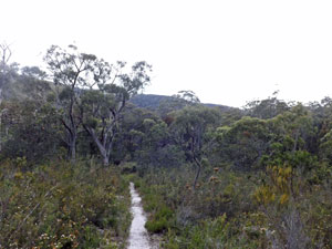 Track across the sandy coastal heathlands |
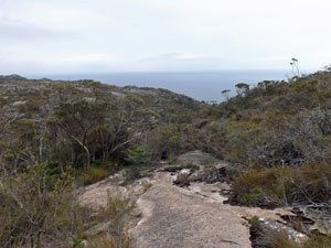
At its northern end, our route diverged from the way in as we turned to follow the Peninsula Track inland. At first, the climbing was gentle and, for long sections fairly level, as we crossed the forested old dune system. Then the climb began, as the track wound its way up the side of one of Mt Freycinet's south-facing spurs. The more we headed inland, the taller became the forest. |
|
||
 |
 |
 |
|
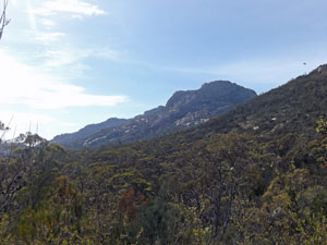
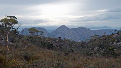
On reaching the spur-line, the path dipped slightly to follow a green fern-fringed creek up its shallow valley. Crossing a saddle, we then followed another creek system down its valley. We may not have lost many metres in elevation, but, when on a big climb, I begrudged every one of them. Crossing the deeply shaded creek, we finally resumed the right upwards trajectory, as the track climbed more steeply through the lush vegetation on the eastern flank of Mt Freycinet, now directly above us. Even though the day was cool, it was very humid and, by the time we reached the open saddle between Mts Freycinet and Graham, our clothes were wet with perspiration. The first drops of rain had also begun to fall, dampening any idea I had of doing a side-trip to the summit of Freycinet (that will have to wait another life-time). |
||
 Grey-clad panorama from Mt Freycinet to Hazards Beach |
 |
 The Hazards from Freycinet Saddle |
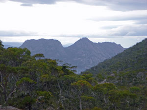
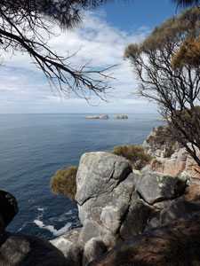
Putting pack-covers on, we started the hardest (and sweatiest) part of the crossing - part climb, sometimes clamber, up the chunky granite boulders of Mt Graham. As we climbed, views opened up to the south of Schouten Island and, beyond it, distant Maria Island - dark land masses on a leaden sea beneath a brooding sky. |
|
 Jana sidling around Mt Graham |
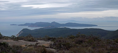 Panorama of the southern peninsula and Schouten Island |
|
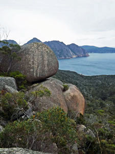
We had now left the forest well behind, as the track took the line of least resistance and brought us up to a large granite dome just below the summit. As well as the views south to Schouten island, we could look down on the The Hazards to the north. It was a great place for lunch and, as a bonus, the sprinkles of rain had stopped. |
|
 |
 Looking beyond Mt Dove to the far blue hills |
|
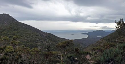
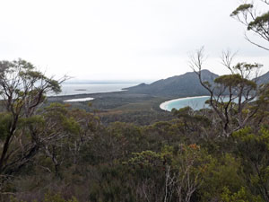
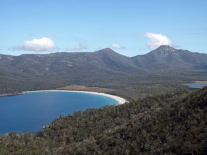
From a little higher up, the northwards views expanded to take in the picture-perfect shape of Wineglass Bay, defined by its thin fringe of white sand. Further west lay the sandy isthmus that not only separates Wineglass Bay from Oyster Bay, but The Hazards from the rest of the peninsula - one day the sea will break through and the future visitor will be standing here on an island.
|
|
Then the long descent began - steeply, and carefully, down an ankle-strengthening path around the salmon-pink boulders and slabs of Mt Graham, to arrive at a flat and slightly boggy mountain-top heathland. We ambled across this before dropping another level via a timber-clad creek system to a second area of open heath. |
|
 The scrubby tops of Freycinet Peninsula |
 Looking across the heath towards The Hazards |
|
|
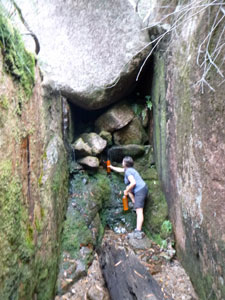
Finally, the track began its descent into the deep, wooded valley of Grahams Creek. It was time to walk quietly and listen. Wineglass Bay campsite has no fresh water, but we were told that water could be collected at one spot along Grahams Creek - just listen for it tinkling in the rocks. "Tinkle, tinkle" went the water as a small stream flowed out of a crack in the rock face, percolated over dark green moss and fell down onto the gravelly creek bed, where it again disappeared. |
|
|
|
|
||
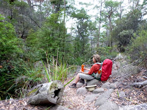
Jana and I clambered down into this lovely little grotto to fill our water bottles, plus an extra bladder - seven litres should make for happy campers tonight and see us out to the trackhead next morning. The downside was that seven litres weighs seven kilos, a big extra drag on hips and shoulders as we continued our descent for another 3 km. |
|||
 View through the trees towards the isthmus |
 |
 Time for a break |
|
 |
 A nice sheltered campsite |
Skirting high above the creek, we reached Quartzite Ridge and the long final descent to the campsite at the southern end of Wineglass Bay. The sky was again threatening rain, so we found a tentsite beneath a low, but wide-canopied tea-tree, brewed a cup of coffee and went for a slow wade up the beach - so good without boots and backpacks. |
||
 |
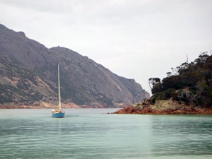 Yacht sheltering in Wineglass Bay |
|
By the time we reached the creek at the end of the beach, the occasional drops were becoming heavier - the time had arrived to retreat to our tent and the "bodgy brothers" shelter contrived from tent flap, poles and poncho. At least we were not shut into our tent and could watch the world go by as we cooked up a warm dinner and contemplated our good fortune in having crossed the spine of the Freycinet Peninsula and beaten the rain. This was sadly not the case for several wet and bedraggled young campers who arrived late from Coles Bay. |
||
Footnote: when cooking up a nice rehydrated spaghetti Bolognese, don't confuse the Parmesan cheese with the powdered milk. |
|
Wineglass Bay to Hazards Trackhead (5 km - 230m ascent - 180m descent) |
The overnight rain finally stopped about 4am - it was good not to hear the pitter patter of raindrops on the tent fly, as there is nothing worse on a camping trip than packing up in the rain. By the time we got up, there were even patches of blue sky appearing - our luck was holding. We took our time packing, as we only had 5km to walk back to the trackhead to complete the circuit and we wouldn't be able to check in to our cabin at Coles Bay until 2pm. We said goodbye to our Swiss friend, Jana, who was heading off early, then had a leisurely breakfast, a morning stroll to the tannin-stained creek at the southern end of Wineglass Bay, and finally we set off ourselves. The incoming waves of the high tide forced us to the edge of the beach as we wandered slowly around the white curve of Wineglass Bay - at high tide it has a very narrow beach indeed. The entrance to the bay became larger as we headed north, past a couple of yachts drifting on their anchors on the glass-green water, to reach the northern end. |
|
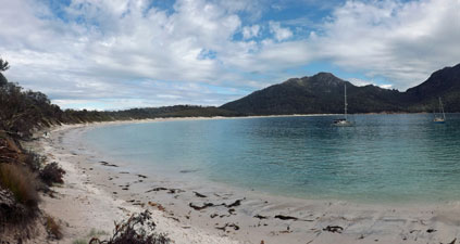 High tide at Wineglass Bay |
 |
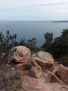
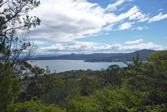
Already lots of day-trippers had climbed over the pass between Mts Mayson and Amos and were sunning themselves here on the sand. With time up our sleeve we joined them. There are few places in Australia where rocky peaks plunge directly into the sea and this is one of them - it was worth a period of contemplation.
|
|
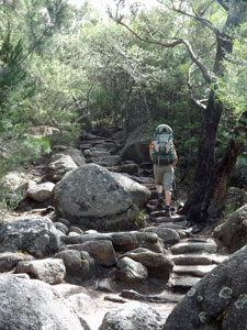 Climbing the steps to Hazards Saddle
Then it was time for the climb, up through the forest on the well-made path, flattish at first but becoming increasingly steep as we pushed on. The many series of stone steps made for easier climbing, but with heavy backpacks on, we still quickly worked up a sweat in the morning humidity. In the 45 minutes it took us to climb to the pass, 115 day-trippers passed us on the way down to Wineglass Bay - such is its popularity. In many ways, it has become a victim of its own fame. |
After taking a breather at the pass, we dropped our packs for the short side-trip to a lookout point that takes in the classic postcard image of the bay and the mountains of the peninsula that frame it. A lovely setting, but spoiled by the high-pitched whine of a drone that one of the visitors was flying to capture his birds-eye video of the scene. Is this what the world is coming to? - places of beauty ruined by this latest techno-fad. "Bloody rude" as the fair but frank Nello commented. |
||
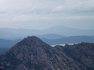
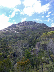 Looking up at Mt Amos |
|
 Rock formations below Mt Mayson |
We left and headed down, leaving the enormos boulders that line the ridge of The Hazards and following the well-formed track down through quiet green forest and past massive granite outcrops. At times gaps in the forest allowed views out over the waters of sunlit Coles Bay and out to the northern fringes of Oyster Bay beyond. Walking down this track was very pleasant, but then walking down any track after a big climb is pleasant. Suddenly, we emerged at the trackhead next to the carpark and our walk was over. It had been a great, if sometimes energy-sapping walk - the colours of the rocks, the sea and the sand of the Freycinet Peninsula certainly lived up to their hype. It is clear that this part of the world is now firmly entrenched in the tourist circuit and, even though part of me somewhat selfishly wishes for a greater degree of isolation, you do meet a diverse and interesting group of people when you hike the Freycinet Circuit. |
|
In particular, a quick thanks to the camp wardens at Cooks Beach for being so informative and hospitable, and to our hiking companion, Jana - we really enjoyed sharing our walk with you on the Freycinet Peninsula. |
|
Bonus - Bluestone Bay walk (5 km - 140m ascent - 140m descent) |
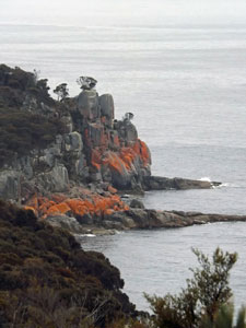
We arrived in Coles Bay late morning, the day before setting out on the Freycinet Circuit and drove out to take in the views of The Hazards, the rocky range that barricades the peninsula, from Cape Tourville in the east. Just before the lighthouse on the cape, a fairly obscure 4WD track heads north towards Little Bluestone Bay. |
|
|
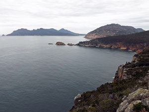 Looking south from Cape Tourville |
 |
|
|
|
|
We parked the car a little down the road and walked the remaining 2 km down through the coastal forest to it. It is in a lovely setting, lined by orange-walled cliffs, with a "beach" of large blue-grey boulders. It was a good way to stretch our legs before the big circuit walk and the images here are included to show this relatively unknown, but beautiful, part of Freycinet.
|
|
|