Prologue
Today we have been sitting on low cliffs below Cape Naturaliste lighthouse watching the distant blows and breaches of humpback whales in Geographe Bay, the last sheltered bit of water before they continue on to their summer feeding grounds in the seas of Antarctica. We were there to check out the start of the Cape to Cape Track, a 135 km walking trail between the two lighthouses guarding the corners of this south western extremity of Western Australia. It will be our first trek in this part of the world. Our plan is to couple this with the southern part of the Bibbulmun Track, a 230 km section from Walpole to Albany that lies a little further to the east. The Bibbulmun runs for almost 1000 km from Perth to Albany; we don't have time to walk the full length and much is in the interior, so our plan is to pick the eyes and walk through the giant forests and the coastal sections. Finally, we want to round the trip off with a couple of day-walks in the Stirling Ranges to get a feel for the curious landscapes of this isolated rugged range, just to the north of Albany. It is home to many endemic plant species, and this is certainly one of the attractions for coming at this time. Southwest Western Australia is a "hotspot" of floral diversity and in spring it is justly famous for its displays of wildflowers.

Please feel free to join us as we explore this intriguing part of the world.

Getting Here - across the Nullarbor


The Nullarbor Plain

Sitting on the cape watching the whales, it seemed hard to believe that only a bit over a week ago we were 4000 km away on the other side of Australia preparing for this latest walking adventure. To get here, we had traversed the continent by car over several days; a long day across familiar terrain of New South Wales and Victoria to Adelaide to spend a few days with family (the following descriptions are dedicated to you Mum), then across the west coast of South Australia, until the gently undulating textured green carpet of mallee finally morphed into a flat plain of pale gold grass, speckled with the greens and greys of saltbush, extending for hundreds of kilometres. We had reached the Nullarbor Plain, that physical and psychological divider of southern Australia into east and west and the reason for Perth being the most isolated large city in the world. We were in new terrain and what a fascinating one it was; the road followed the southern edge of the plain, where sheer cliffs plunge 80m down into the deep blue waters of the Great Australian Bight for kilometre after kilometre without a break. These waters are the breeding grounds of the southern right whales and we stopped at the head of the bight to watch several of these 80 tonne creatures cavorting in the waters directly below the cliffs - superb!


Cliffs of the Great Australian Bight

The V-shaped blow of a southern right whale


The endless line of cliffs


Right whale mother and calf

100m cliffs at the edge of the Nullarbor

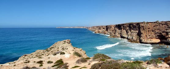
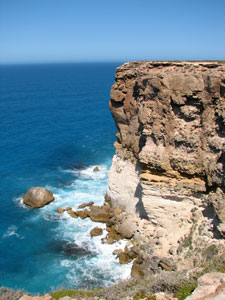
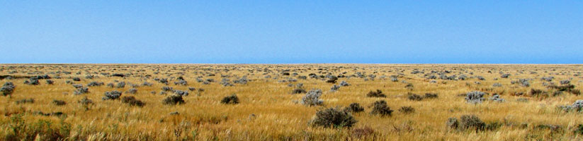
Continuing on, we crossed the border into Western Australia, passed through the area of "Cocklebiddy time", an unofficial time zone used only by a few hundred locals and the tourists who pass by this isolated part of the country, and on to the "Roadkill Highway". This is a 146km dead-straight section of road where breakfast clubs of fat black ravens dine each morning on the fresh carcasses of kangaroos and wallabies, flattened by road trains that pass in the night. Finally the trees returned and gradually a greeness began to reappear in the landscape - we had finally reached Perth. It was a chance to recover from the long drive and spend a couple of days with Pete, a "long-lost" cousin and childhood mate, whom I had only seen once in the past 35 years. It was as if time had not intervened - thanks Pete and Mary for a great couple of days.

So, even before taking a single serious walking step, we had had a fascinating and memorable week. Nonetheless, we are here to walk and the sense of anticipation of another long trek is beginning to build up - it is time to be on our way.