
| An Introduction to Canyoning |
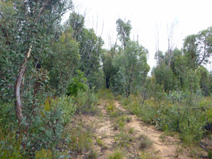
Much of the the World Heritage listed Blue Mountains is comprised of an elevated sandstone plateau. In fact it is a dissected plateau, where, over the eons, water courses have eroded deep canyons and gorges in the sandstone. Many of these are slot canyons, being much narrower (in places less than a metre wide) than they are deep. The Wollemi Wilderness in the Blue Mountains has one of the highest densities of slot canyons in the world - there are over 100 known canyons, many of which were only discovered in our generation and some which probably remain undiscovered. This seems strange in an area only a couple of hours drive from a city of over 5 million people, but attests to the remoteness of the micro-world of canyons where pristine environments await the adventurous. |
||
 Dumbano Tunnels |
 Rocky Creek Canyon |
 Wollangambe Canyon |
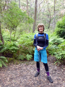
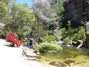
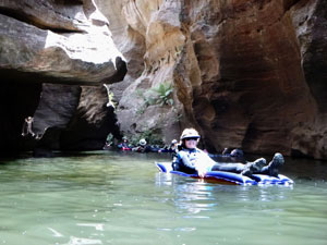
| This week-end would give the fair Nello and I a chance to visit that world, as Bob and Karen, two members of our bushwalking club who live on a bush block in the Blue Mountains, played host and guide to a group of 16 from the club. Some of the group were quite experienced canyoners, others like us were relative novices, but a great week-end was had by all, as Bob and Karen showed us a range of canyon types. We started with an easy walk through the Dumbano Tunnels, which gave us an appreciation of the claustral ambience of the slot canyon and prepared us for the next day in Rocky Creek Canyon. Rocky Creek is rated one of the best in terms of canyon aesthetics but technically easy, although it does require some rock-scrambling, ropework and swims in deep cold pools - it is the real canyoning experience. Our last canyon was very different, the much wider and deeper Wollangambe Canyon, where the best means of transport is an inflatable air mattress to float down beneath the tall cliffs in the sunlight. While doing this, we got the chance to explore one last slot canyon, a dark and almost sunless gash in the sandstone called Kelvinator for its fridge-like temperatures. It was a great three day introduction to canyoning - thanks to Bob and Karen for organsing and hosting it and to our club colleauges for their conviviality. An attempt is made below to capture the atmosphere of the Blue Mountains canyons, but in reality there is only one way to do this - go and explore a canyon! |
||
|

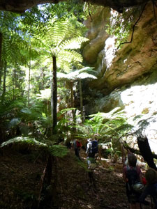
Dumbano Tunnels (7 km - 180m ascent - 180m descent) |


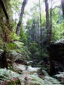
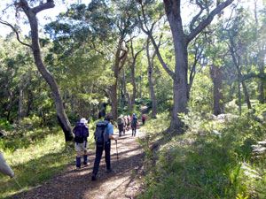
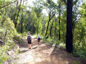
We woke to a Blue Mountains summer day – single digit temperatures, occasional drizzle and fog. Oh well, in a canyon the weather becomes less important. We delayed our departure until 9am to allow the fog to lift and then headed off via the bumpy forestry roads to the unmarked trackhead in the middle of Newnes State Forest. As we set out in our waterproof gear, we looked more like a group of winter walkers. The track led out across the regenerating forest, with its dense understory and blackened trunks sprouting green epicormic shoots after the fires of two years ago. Leaving the wider track, Karen and Bob led us down a steepening slope, first on a narrow foot pad and then heading cross country, as Karen's GPS led us down through fairly open scrubby forest to the upper reaches of Dumbano Creek. |
||||
 |
 |
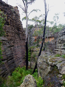
 Forest of Newnes Plateau regenerating after the 2011 fires |
 |
 |
|
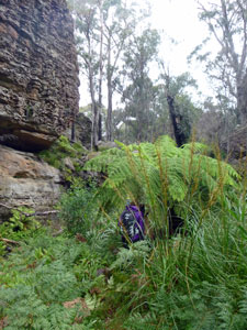
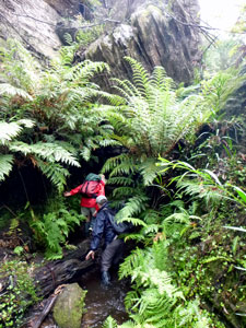
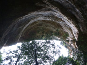
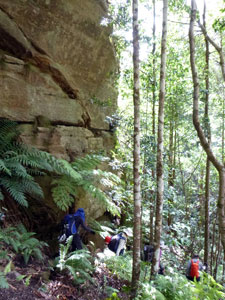
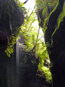
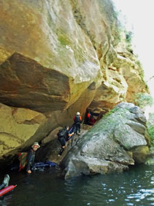
The appearance of large sandstone blocks ahead signalled the creek line and we dropped quickly into it – it was time to take off our boots and put on our creek-wading footwear (volleys for some, teva sandals for the fair Nello and I). Before heading towards canyon land, we made a short detour in the opposite direction to visit a superb rock overhang – high sandstone roof above, a backing of lush ferns and a small streamlet flowing through. It was a very pleasant (and dry) place to take a break as another light shower passed by.
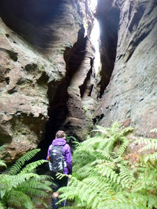
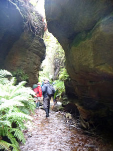
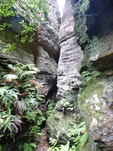
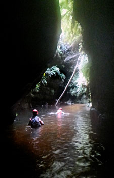
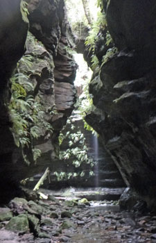
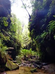
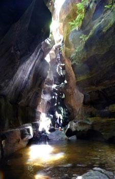
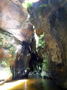
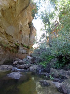
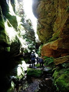
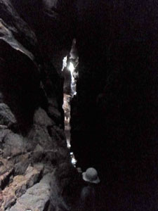
Then it was onwards, as Bob and Karen led us down Dumbano Creek, as it tucked its narrow course right against the sandstone cliffs. We picked our way through the dense scrub alongside the river to reach the first piece of spectacle, a short drop and wade to follow the creek through a low rocky tunnel into a new valley system. The walls seemed to be closing in as we picked our way down this valley, only to head northwards, as Dumbano Creek turned directly into the sandstone cliffs following a narrow cleft. |
|
 Wading down Dumbano Creek |
 Massive chockstone wedged above the creek |
 The canyon narrows |
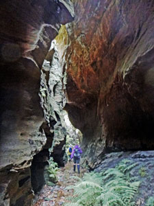
 Entering the Dumbano Tunnels |
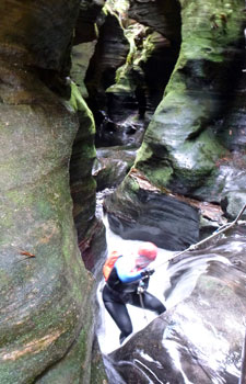
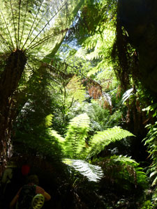
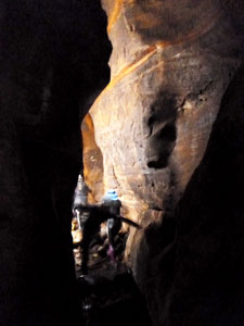
We were now in the Dumbano Tunnels as the walls constricted even more and we waded down the shallow creek on a labyrinthine course through this deep and winding gash in the sandstone plateau. An even darker and narrower gap opened in the cliffs to the left, bringing down a small side creek. |
|||
 Big coachwood in the ferny grotto |
 |
 Looking up at the roof of the overhang |
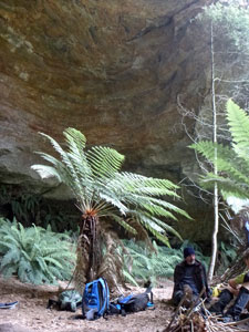
We headed up it to reach another beautiful overhang – a ferny grotto deep within the sandstone, accessible only by these narrow slot canyons. It was a good place to drop our packs and do a bit more exploring. |
||
|
|
|
|
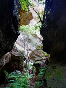
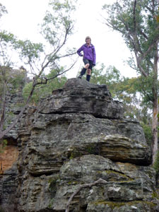
Leaving the overhang, we first followed a dog-leg in the creek into the narrowest and most spectacular section of canyon, which brought us out into a small, fern-filled and rock-walled amphitheatre. We then retraced our steps to enjoy lunch in the ferny grotto, followed by a climb up onto the sandstone plateau to see what these canyon lands looked like from above. It was incredible how the rounded scrubby tops belied the amazing landscape that lay beneath. |
|||
 Lunch beneath the overhang |
 Looking down on the grotto from the plateau |
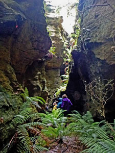
Once more into the canyon ... |
 ... and its spectacular interior |
It was now time to retrace our steps, giving us one more opportunity to enjoy the exquisite Dumbano Tunnels. Eventually we arrived back at the site of the first cave. It was now time to change back into dry boots and head off on a new route home – climbing gently cross-country along the scrubby slopes above Dumbano Creek, before picking up an overgrown 4WD track that led us back up the slope to our inward route and the cars. |
 |
 The route home through Newnes Forest |
|
Despite the passing showers and cool weather, it had been a great introduction to the canyons of this region. It certainly whet our appetites for tomorrow, where we would be donning wetsuits and hitting the deeper pools of the even more impressive Rocky Creek Canyon. |
||
|


Rocky Creek Canyon (6 km) |
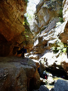
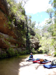
The weather was on the improve – blue patches in the sky, cool but not cold – as we headed out in Bob's old troop carrier along the long and bumpy dirt road through Newnes State Forest. Ahead lay the starting point for the Rocky Creek Canyon and our first taste of what "real" canyoning is. Rocky Creek, only discovered 40 years ago, is graded "easy" for technical difficulty, but 10/10 for canyon quality – a chance to visit a not too difficult canyon with an apparently superb atmosphere was not to be missed for our class of Canyoning 1A. |
|
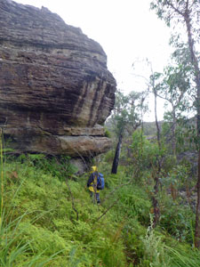
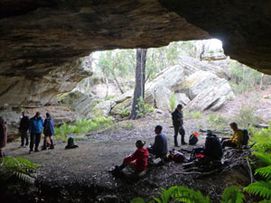
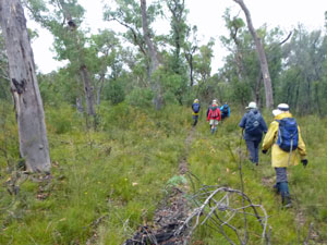
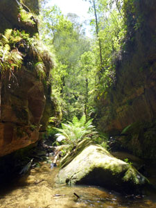
We left the cars, checked out wetsuits, bike helmets and dry bags for gear, and headed down into the dry scrubby forest of the Newnes Plateau. Shortly after the party split into two, with a group of more experienced canyoners heading off to descend the short but adrenalin-pumping Twister Canyon before continuing on to rejoin us for the exploration of Rocky Creek Canyon. Members of Canyoning Class 1A continued on – the track began to descend more steeply as it entered the lusher, denser vegetation of the steep creek slopes. Soon the first walls of grey sandstone started to appear and we knew that we were in canyon country. The track led us on through dense stands of fern beside rocky outcrops as it headed into the depths of the increasingly moist creek system.
A bit of ropework took us down another level where we followed the muddy track down, passing beneath rock overhangs, criss-crossing the small side-creek and eventually spilling out onto a rock platform at its junction with Rocky Creek. |
|
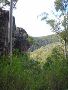

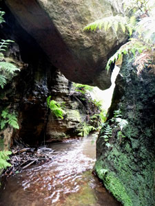
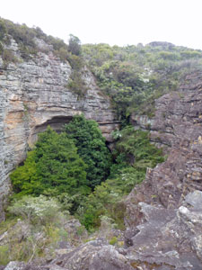
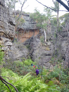
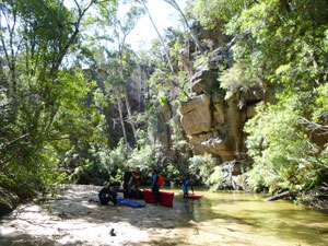
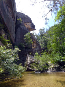
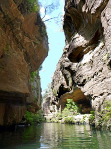
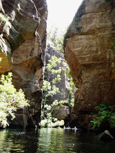
I had thought the landscapes so far to be impressive, but here at the entry to the main canyon, we were looking in to a whole new world. Rocky Creek carved its way through the rock slab to tumble over a foaming waterfall and then bubble and tumble its way into the deep cleft in the rock wall that faced us. |
||
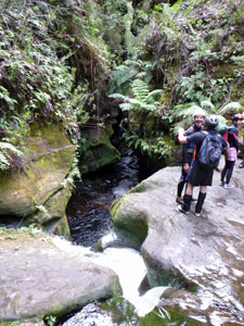 Looking into the mouth of Rocky Creek Canyon |
|
 Time to explore |
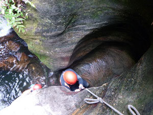
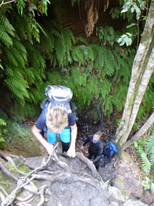
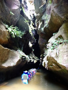
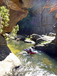
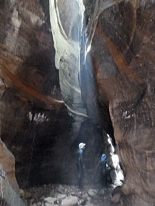
It was now time for wetsuits and helmets. Our passage into the canyon lay just to the right of the waterfall – a circular tube near the edge of the rock slab with a rope for assistance. We were about to enter the netherworld of Rocky Creek Canyon. We were fortunate to have Bob's two sons, Jamie and Tyson, both experienced canyon guides with us. |
|||
 Descending the first waterfall |
 Looking into the "Washing Machine" |
 Descending to the next level |
 Mossy walls of the big pool |
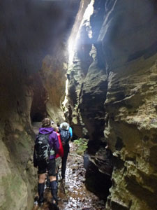
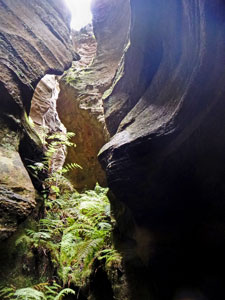
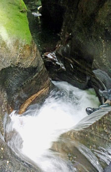
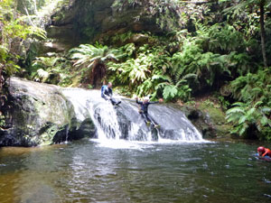
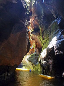
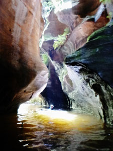
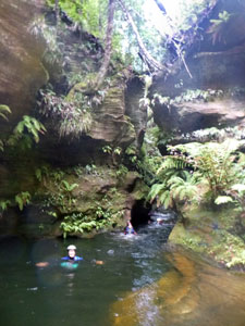
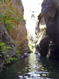
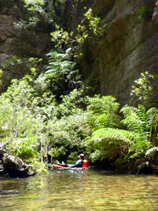
It is impossible to describe the sublime and dark beauty of the canyon. Suffice to say that we waded and swam our way down the icy waters of the creek, picking our way across small cascades as well as larger ones like the twisting, rushing torrent of "The Washing Machine" or sliding down a broad water slide. Constricted sections with jumbles of green mossy rocks were separated by broader deeper pools, where we semi-swam and semi-floated our way down beneath the narrow, tall and amazingly convoluted walls. |
||
|
The photos that follow will tell the story, though in the crepuscular light and watery environment, my small (albeit waterproof) pocket camera struggled with photo quality. It did, however, capture the atmosphere.
|
|
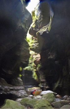
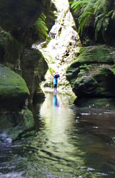
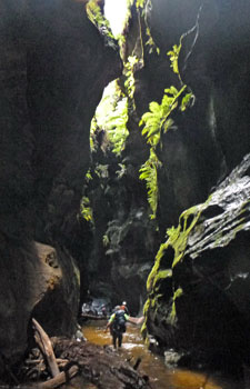
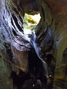
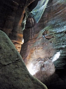
Once past the big slide and a light-filled open section where ferns covered the walls, we entered the spectacular inner canyon. Here the walls closed in above and sunlight barely forced its way beyond the water-sculpted upper walls. At times, the canyon opened out a little and shafts of sunlight penetrated to the floor, at times we passed under the fine cold shower of a small waterfall sprinkling down from the heights and at times we entered an even darker world as we worked our way past tunnels caused by fallen slabs of sandstone. |
|||
 Ferns filling a wider section of the canyon |
 Crossing a deep pool |
 Reflections from a shaft of sunlight |
 Sunlight on a canyon waterfall |
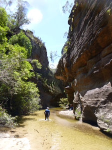
Picking our way over rocks and cascades, wading deep sandy stretches and swimming the length of even deeper long and icy pool beneath the ethereal light of this sublime canyon, we eventually emerged at a sunlit opening near the junction with Budgary Creek. It was the end of the canyon and time for lunch in this picturesque setting. However, we couldn't stay long, as the body quickly cools down when it has been in very cold water and activity suddenly stops, so it was back into the dim light of the canyon for the return trip. |
||
 Emerging back into the sunlight |
|
 Back into the canyon for the return journey |

The way back lost nothing by comparison with the way in. Even when we knew what was coming, the joy of seeing it remained. This, coupled with the frisson of climbing up obstacles such as "the Washing Machine" made for a great canyon experience. Once last bit of tricky rope work and we emerged one by one onto the platform at the entrance, followed by a lot of shuffling and shifting as we all got out of wet wetsuits and put on our dry walking clothes for the trip back to the car. |
|||
 |
|
|
 |
| Homage to Rocky Creek Canyon (on the way back out) | |||
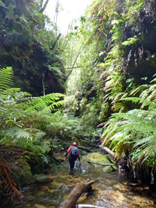
We retraced our steps for a large part of the way, before Karen led us off-track to continue up the narrow gully of the side stream. The slope was gentle at first as we wandered beneath ancient coachwood trees and tall tree-ferns, hemmed in by vertical rock walls on both sides. It was an old and silent world. |
 The way home up a valley of old coachwoods.... |
 ... beneath tall sandstone cliffs ... |
 ... and past groves of tree-ferns... |
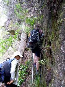 .., with one last ladder to the cliff top |
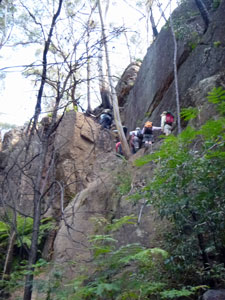
The gradient soon steepened as we changed direction to make our way up the wet earth slopes to reach the rock walls. Here, we found the passage through the cliff face, helped by a rickety old ladder that some kind soul had installed. Once above the cliffs, the forest changed dramatically from the lush canyon vegetation to the dry scrubby eucalyptus of the plateau. The cars were but a short distance away and it was an exhilarated, but tired group that reached them. From our limited experience, the fair Nello and I agreed that Rocky Creek Canyon certainly deserved its 10/10 rating. |
|||
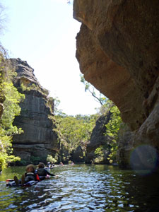
|

Wollangambe Canyon (8.5 km - 410m descent - 410m ascent) |
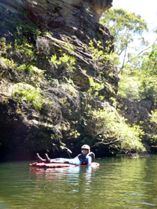
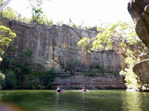
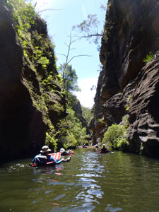
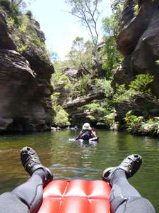
Over the years, the pages on this site have described trips on foot, by bicycle and 4WD vehicle, and in a canoe, sea-kayak or yacht. Today we add another means of transport –the humble air mattress. Our third canyoning experience was to be different again, as Bob and Karen had planned a trip down the Wollangambe, a bigger and more open canyon than those we had explored to date. With its long sections of still deep pools, an inflatable air mattress (or li-lo) is the preferred method of descending the river that flows through it. This trip would be an upper body workout. Leaving the cars at the Mt Wilson fire station, our group headed towards the deep valley of the Wollangambe, passing first through the lush green forest of the basalt tops, and then through the drier more open forest of sandstone slopes. Passing the large outcrops of sandstone that signalled the start of canyon country, Karen led us steeply down into a fern-filled side-creek, which we followed to its junction with the Wollangambe River. |
|
 Track through the rich basalt forest |
 Hard to believe there is a canyon out there |
 Preparing to launch at Wollangambe River |
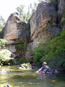
It was a perfect blue sky day, as we pumped up the li-los, donned wetsuits and checked dry-bags on a lovely section of sandy beach and cold, but clear shallow water. Then it was off to explore the canyon. Almost as soon as we launched, we were in it – paddling slowly down a long deep pool with vertical sandstone walls on either side. It was easy to drift down the river as it curved its way gently and deeply through the plateau, looking directly up to the tree-topped cliff edges and blue sky passing slowly by, with only the gentle splash of paddling hands and occasional shimmer of sunlight reflected on to rocky overhangs. |
||
 Setting out down the river .... |
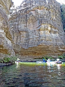 .... and into the canyon |
 |
 |
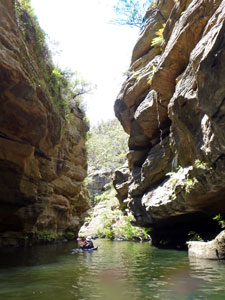
Not long after passing a large sweeping bend overlooked by an enormous cliff-face, the sound of rushing water signalled the first blockage, where a jumble of boulders had long since turned the river into a series of cascades. It was time for our first portage, carrying the li-los through the uneven rocky terrain and scrubby riverside vegetation. |
|||
 Canyoning is such hard work |
 Cliff-face at the big bend |
 Emerging from a scrubby portage |
This became the pattern of the day – long, leisurely paddles on the li-los followed by short scrambles through scrubby bush, clambering over water smooth rocks next to the cliff face, or picking our ways across boulder-strewn shallows as we passed the occasional constrictions and jumbles of fallen boulders. |
||
Time for a slow drift |
|
 Rock jumble blocking the river |

|
 Tricky descent to the river |
 Heading down the narrows |
|
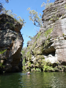
On reaching a sandy beach, we stopped for a pleasant lunch in the sunshine before yet another long deep pool took us past even taller cliffs. It was time for a slow paddle down the river beneath these magnificent sandstone walls.
|
|||
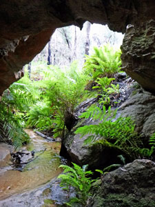
Just beneath one particularly impressive cliff, shaped like the head of the sphinx, we landed at a sandy beach in a sun-filled basin. On the left bank, a narrow gap cut back into the cliff-line – we had reached Kelvinator (aka Water Dragon) Canyon, a slot canyon opening into the Wollangambe, and it was time for a little exploration on foot. |
|||
 View from a li-lo |
 Entering a tight section of the river |
 The Phoenix Rock |
 The mossy entry to Kelvinator Canyon |
|
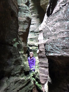
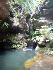
The first part of Kelvinator was a narrow but open-topped gap, filled with mossy green boulders and ferns. We followed the small water course upstream for a short way as it led us into the inner canyon, a very different place. This was an extreme slot canyon with its bizarrely water-sculpted walls fitting together like jig-saw pieces that had been left with a small gap between. The atmosphere was other-worldly – very dark, with the occasional shaft of sunlight penetrating to the floor. Scrambling over the uneven floor or wading the deep cold pools of water, we pushed deeper into the canyon. Wading chest-deep through icy water in a 30cm wide gap in near darkness has a way of focussing the senses. At one stage, we entered a more open cavern, where the sunlight poured in to reflect off the steam of exhaled breaths – you could see why this canyon was called Kelvinator. Not long after, we reached the end (at least for people without ropes) – a silvery water fall tumbling out of a sunlit, fern-filled hole above and tumbling down the rock face into the dark void – magnificent. After the obligatory cold shower beneath the falls, we retraced our steps back to the warm sun of the Wollangambe. |
|
|
 Sunlight bathing a canyoner |
 The waterfall at the back of Kelvinator |
 Canyonscape |
 One last swim and we're out |
Then it was time for the flotilla of li-los to make one last long slow paddle down this magnificent canyon before a very small yellow arrow on a very large flat rock-face marked our exit point (pity the person who does not see this, for apparently a 4m high waterfall awaits them). |
||
|
|
|
The fallen tree and rock platform alongside a sandy beach at the exit point were soon draped with deflated li-los and wetsuits drying in the sun, as we changed back into dry walking gear (at least our undies were in the dry-bag that sealed properly!). |
||
 |
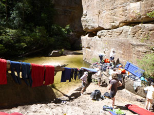 Drying wetsuits and li-los at the exit point |
|
 The route up through the cliff-line |
There was one last frisson left, as the track out led us steeply up a creek to an exposed rock face that provided the route through the line of cliffs – following a ledge along the face, we were obliged to scramble directly up the last few metres with the aid of some exposed tree roots for hand-holds. |
|
 |
 On the road home |
|
With our backpacks heavy with wet li-los and wetsuits, it was a long steady slog back up through dry sandstone vegetation to the rich green basalt vegetation of Mt Wilson and on to the cars. The wonders of the Wollangambe Canyon, and indeed they are many, must be earned. |
||
|

