
| Cycling the Danube in Serbia (part 2) |

Day 5 - Srebrno Jezero to Donji Milanovac (80 km plus 2 km walking) |
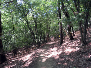
What a perfect day to ride into the Iron Gate - clear blue sky, cool temperatures and barely a breath of air. We rode quickly through the built-up area to pick up a cycle path along the edge of the Danube, with the green hills of Romania backing its silky morning-grey water. The path led us in to the next town of Veliko Gradiste, for a bit more street riding and a chance to watch a bit of road rage between two irate drivers. |
|
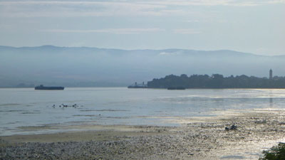 Misty morning on the Danube at Veliko Gradiste |
 Looking across the river from Serbia to the hills of Romania |
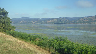
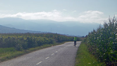
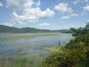
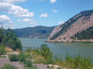
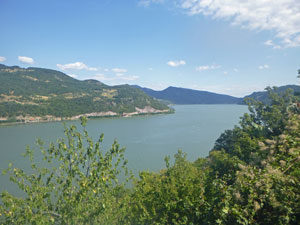
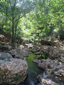
From Veliko Gradiste, we had one more crossing of farmland - maize, sunflowers and pockets of forest. On reaching the village of Vinci, the Eurovelo 6 signs led us back on to the riverside cycle path for a smooth and pleasant pedal along the Danube's edge. Here the Danube divides into two channels, but on passing the village of Usije, these collapse to form a large pseudo-lake (I suspect this is due to the big dam built way down stream in the 1960s). |
|
|
|
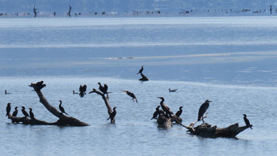
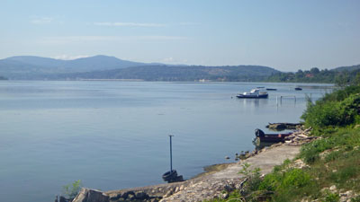
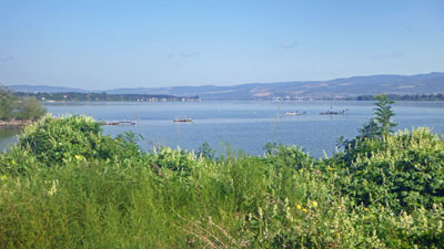
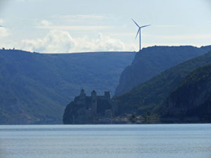
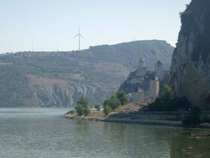
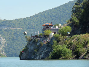
Origins apart, it was a lovely setting - lots of waterbirds sunning themselves on logs or dabbling in the shallows, the wind turbines slowly rotating on the distant hills, and the increasingly larger silhouette of a castle in the distance. We were rapidly approaching the gorge mouth, but first a coffee stop to enjoy this scene in a riverside cafe in Golubac. |
||
|
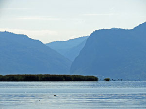
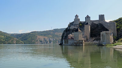
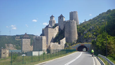
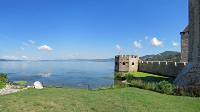
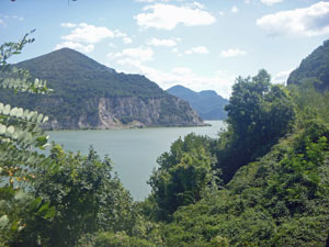
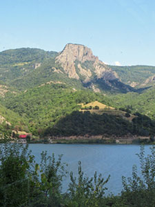
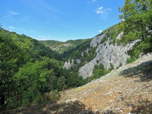
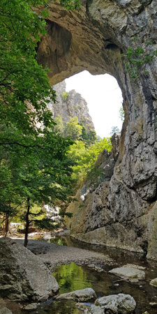
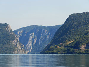
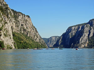
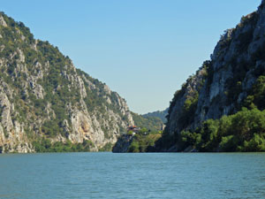
The precipitous karst walls of the Danube dramatically shrink the river from 5.6 km wide in its bulging lake to 300m wide as it enters the gorge to cut thorugh the Southern Carpathian Mountains. Guarding this entry is Golubac Fortress, a superbly restored medieval castle (its 14th century origins clouded in mystery, taken by the Turks in the mid-15th century and restored by the Austrians in 2014). We stopped here to visit the castle, built into a jagged karst outcrop, and learn a little about the complex and (for us) unknown history of the region. |
|

|
|
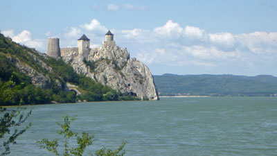
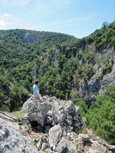
 The Iron Gate from in outside the gorge |
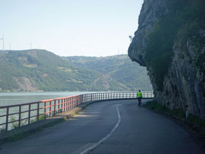
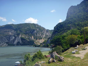
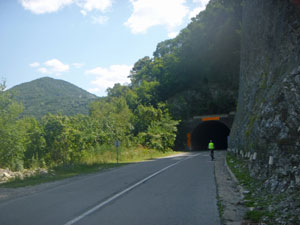
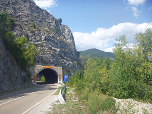
Leaving the fortress, we cycled through a 300m long tunnel that brought us into the gorge proper. The limestone walls topped with forest gleamed white in the sunlight (a pity that someone decided it would be good to put a quarry on the Serbian side). Luckily the rest of the gorge and surrounds on the Serbian side is protected by the Djerdap National Park. We were now on the main road, but it was surprisingly not that busy, as we meandered along beneath the shade of the southern gorge walls. |
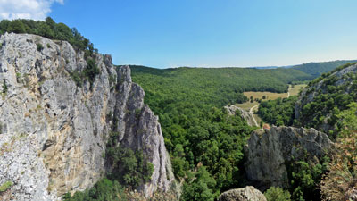
 The Iron Gate from inside the gorge |
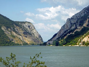
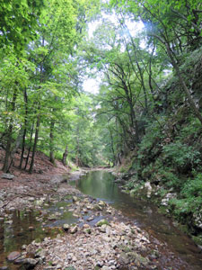
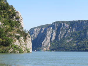
Across the river, the Romanian side began to broaden out into a softer hilly landscape. The river widened and slowed with patches of yellow-flowering waterweed along its edges. We pushed on past the tiny villages of Toma Brjnica and Dobra, set at the mouths of long, green-clad side gorges. The latter had a small coffee shop, which proved a pleasant place for a rest stop. |
 A softer lower landscape as the river widens |
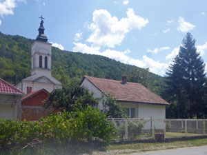 The church in Dobra |
 The gorge walls close in again |
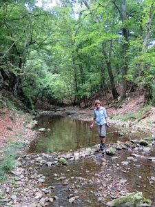
After Dobra, the Romanian hills again began to close in - becoming more sheer with white limestone rock faces, and the river itself was wedged in to a narrower course. We reached our first serious climb, which took us higher up the gorge wall to begin a passage through a series of tunnels and bridges that traversed this sheer landscape. There were 15 tunnels in all, ranging from 60 to 260m long, some nicely straight and open, others curving and dark - we were glad for the bike-lamps provided and the high-vis vests. In between the tunnels were several short but high bridges, that cross the narrow side gorges cutting into the Iron Gate. |
||
 About to enter one of the 15 road tunnels |
 |
 Riding through a tunnel |
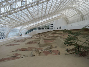
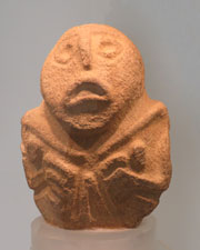
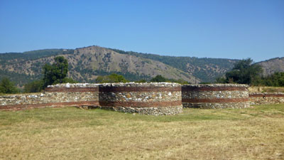
This was a spectacular section that ended with the mesolithic archaeological site of Lepenski Vir, set below the impressive Romanian peak of Treskovac towering 700m above the river. We could see the metal and glass housing of Lepenski Vir on a steep tree-clad bank in the distance and on reaching the junction, coasted down to the parking area for a 1km walk to it. Beneath its high roof lay the exposed remains of a village built by early Europeans who lived here from 9500 to 6000 BC. It was eye-opening, with well preserved statues and artefacts, as well as burial sites. |
|
|
 The well-preserved mesolithic ruins of Lepenski Vri |
 |
|
By now, we were deep in the gorge with only 17km to ride for the day, including two more tunnels and a long steady climb, as the road veered away from the edges to cross the hills behind. The one good thing about a climb is that there is almost always a long sweeping descent afterwards - wheee! |
||
 Last tunnel before Donji ...... |
From the bottom of the hill, we could see our destination, Donji Milanovac, in the distance and a quick, flattish pedal around the river's edge brought us to it. After a slightly worrying 20 minutes mix-up at the Tourist Office, we found our little studio apartment, which was cool and pleasant - a good thing, as we had opted to spend the next couple of days here and just enjoy being in the centre of the mighty Iron Gates. |
 ..... and the river beyond |
|


Time off in the Iron Gates and a walk to the Vratna Gates (5 km - 210m ascent - 210m descent) |
So did we need another day off in Donji Milanovac - probably not - but did we enjoy it - definitely yes. A sleep in, coffee at a riverside cafe as we watched the Danube slowly flow by on a warm sunny day, a bit of washing, a few emails, watching the long cruise ships pull in to disgorge their passengers onto buses for a trip to Lepenski Vir archaelogical site (secretly, being glad we were watching and not on one of thes floating hotels), listening to the strains of Serbian live music float across the village to our balcony from some nearby fete. No, it wasn't a bad day at all. |
||
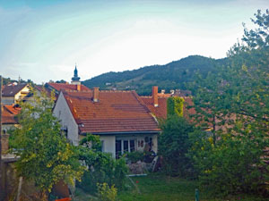 Village houses in Dinji Milanovac |
 |
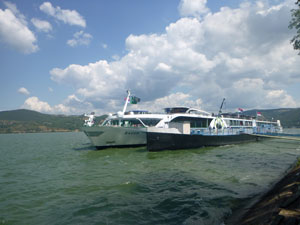 Danube cruise ships docked at the port |
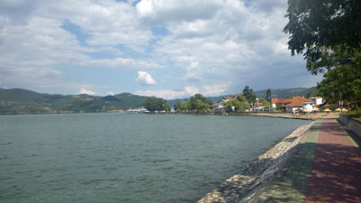 The waterfront at Donji Milanovac |
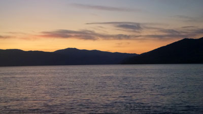 Danube River sunset |
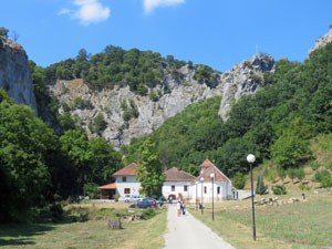
The following day I had planned to be a little more active - a walk in the nearby Vratna Canyon, a small canyon that cuts its way through the limestone hills of the Southern Carpathians in the Danube hinterland. The weather was once again warming up, as we set out in a taxi for the short in distance, though long in time, drive up the narrow winding road into the green forest clad hills. It would have been even longer if our chauffeur had not been an aspiring rally driver. |
|
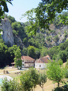
 Serbian Orthodox monastery of Vratna |
 Forest path to the Vratna Gates |
 Above the karst cliffs of Vratna Gorge |
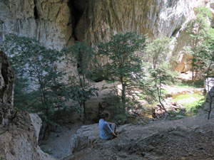
On reaching the entrance to the canyon, guarded by a monastery founded in the 14th century (but torn down early this century and rebuilt after World War 2), we set out on foot. The path to the gorge lay to the right and climbed quickly up into a shady grove of trees and a cloud of midges, that delighted in flying about our faces. |
||
The climb was short and we then quickly dropped down into the canyon (luckily the midges preferred to stay in the forest), where the main attractions lay - two natural stone arches carved into the limestone by the river. The first and smaller one, Mala Kapije (22m wide, 34m high and 15m long), was tucked away in the bush - a short section of stone hopping back and forth across the rocky bed of the Vratna Stream brought us to the point where we could see the water tumbling on beneath the stone bridge and down into the rough and overgrown canyon floor. |
|
||
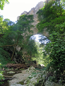 Mala Kapije (The Little Gate) |
 |
 Vratna River |
|
 Inside Vratna Gorge |
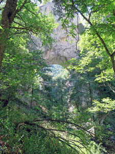
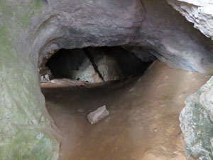
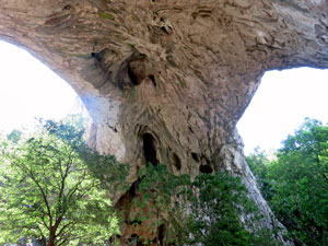
Upstream was much more accessible and, a few metres further up lay Velike Kapije (23m wide, 26m high and 45m long). It was a more impressive bridge, the arch of which could be viewed from beneath. We could also climb part way up one side to peer into the opening of a cave system associated with these limestone cliffs.
|
 Crossing the Vratna River |
 Contemplating the interior of the arch |
 Cave entry in the karst walls |
 A curious view of Velike Kapije |
Time is money, especially when a taxi is waiting, so we did a quick exploration a little deeper into the shady, tree-filled canyon, skipping from side to side across the river. Then it was back to Velike Kapije, to follow a steep path to the top of the cliffs for some nice views down the canyon and out over farmland and forest beyond its entrance. |
||
|
On the way back out, we detoured to climb Vidokovac, the cross-topped limestone outcrop that formed a backdrop to the monastery, before descending through midge-forest and paying a visit to the little chapel in the monastery grounds. Although not ancient, the walls and ceilings were covered with paintings and iconography - a gallery of byzantine artwork, well worth the visit (but no photograps allowed).
|
|
Thus ended our walking diversion and we zoomed back down to Donji Milanovac to ready ourselves for the final day of our Danube cycling tour. We were really looking forward to this, because the first 30 plus km would be by boat. It seemed a shame to come all this way without seeing the Iron Gates from on the water and there were several operators of tour boats that could rectify that. Tomorrow, our trip would start with a Danube River cruise. |
|

Day 8 - Donji Milanovac to Kladovo (26 km plus 34 km by boat) |
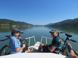
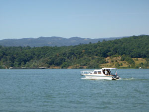
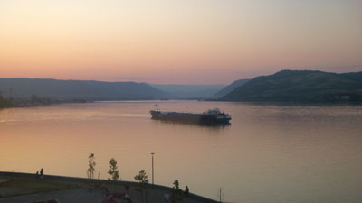
It is a balmy late summer evening in eastern Serbia, and the fair Nello and I are sitting at a riverside cafe in Kladovo, sipping ice cold Zaycharsko beers as the lights of the Romanian city of Drobeta ripple their reflections across the waters of the Danube. What could be better ..... the whole day, in fact. Our decision to charter a boat and do the first part of this day on the water instead of riding had been a master stroke. It had dawned a beautiful day - clear blue skies and barely a breath of wind. We left our small apartment and rode the couple of kilometres around the edge of the river to Porech Bay, where our boat and captain Boban were waiting. It was a surprise to also meet Alexander, a park ranger in the Djerdap National Park, which takes in the Serbian side of the river here. He had given up a day of his holidays to help out his mate, Boban, by acting as tour guide for the anglophones. With his excellent English and knowledge, we learnt a lot about the cultural and natural history of this region as we cruised down the river - it was as if we had our own personalised tour. |
|
|
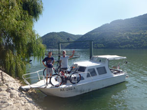 Our River Danube cruise ship ...... |
 ..... with superb front deck views |
 A quadruple barge plying the river |
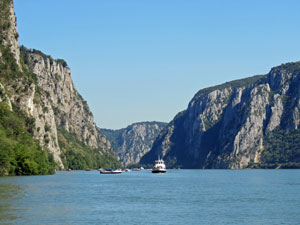
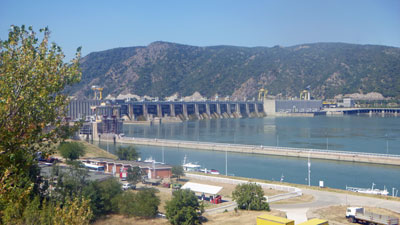
Boban, tied the bikes to the railings of his boat (room for 8, but just the two of us) and we set out, leaving the bay to enter the Danube, 3km wide at this point, and head downstream on a long wide reach of the river. It was lovely on the water, cutting through the cool morning air at a leisurely pace - a quick shot of Serbian raki and strong coffee to ensure we were awake. Soon we were out the front of the boat looking ahead, as in the distance the cliffs closed in to form a narrow sheer-walled gorge. Since the construction of the Djerdap Dam downstream, the water levels here are 30m higher than they once were, flattening out what had been the most dangerous region for navigation. While the higher levels have made it easier for boats, it remains a spectacular place to see from the water. As the gorge narrowed, we could see the road climbing up, through long tunnels, to the top of the cliffs - it would have been a long, hot ride, with more restricted views. Doing this by boat was definitely a good idea. |
|
 Approaching the narrows of the Iron Gorge ..... |
 .... where the river knifes through the karst mountains ... |
 .... exposing dramatic cliff faces |
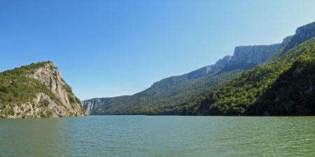
The narrows were spectacular - the cliff-lined peaks of Miroc Mountain rising up to 770m on the Serbian side, and the sheer limestone face of Ciucaru Mare with its water-level caves on the Romanian side. As we entered this section, a wind funnelling between the walls began to create small waves - and Romanian speedboats, loaded with tourists, created even larger ones. The Romanians have developed an extensive tourist infrastructure on the river here, based around the town of Dubova. Dubova sits on a large "gulf" in the Danube, a place between two sets of narrows where the river has ballooned out like a giant aneurism. Just before entering the gulf, the Danube tightens to its narrowest point in the gorge, 140m wide but 70m deep. |
||
 Romanian tour boats waiting their turn ..... |
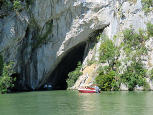 .... to visit the Ponicova Cave |
 A second set of Narrows |
Beyond the gulf we enter the second set of cliff-lined narrows, the entry marked by an old balloon station. Before the dam, the river here was too narrow for boats to pass and the stations used a system of large silvery metal balls to signal which direction had right of way (the boat captains gave way to river pilots to navigate the length of the Iron Gates, such were the hazards). |
||
 The old pilot station |
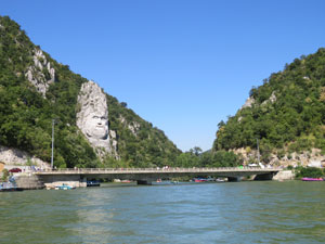 Romania's Rushmore - the 43m high carving of Decebalus |
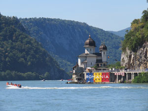 Passing an Orthodox Monastery on the Romanian side |
A little way on, we passed a second balloon station on the Romanian side that had been converted into an Orthodox monastery, followed by two very different carvings in the rock-face. The first, a 55m high carving of the face of Decebalus, king of the Dacians (created only 20 years ago and paid for by a very rich Romanian - some say the face resembles him more than the ancient king), the second, the Tabula Traiana, a 2m high tablet carved into the rocks in 100 AD to commemorate completion of the road cut through the gorge by the Roman emperor, Trajan. I know which one I prefer (but why, oh why, do graffiti artists have to leave their mark). |
||
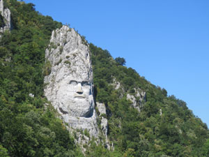 Decebalus, King of the Dacians (carved in 2004) |
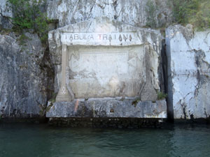 Tabula Triaiana - carved by the Romans in 100AD |
 Farewll to Boban and Alexander |
Then, once again the riverside landscape opened up and we headed quick across to the village of Tekija, which like all villages along this section was relocated after the dam waters drowned the original locations. It was time for us to disembark and hop on the bikes again - but not before a lunch of catfish soup and bread, overlooking this broad and picturesque reach. |
|
|
The bike ride was, naturally, a bit anticlimactic - a pleasant ride in the shade of the hills up to the huge wall and locks of the Djerdap Dam, a quick visit to the ruins of an old Roman encampment known as Diana Fort, and a ride in the open sun along the last of the main road and through the back streets and riverside path of Kladovo. What a great day it had been - the most spectacular scenery of our Danube adventures. Thanks to Boban and Alexander for showing us this part of the world. |
|
|

