
| Great Keppel Island |
About |
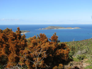
Great Keppel Island is very different to Lady Musgrave Island, being a continental island rather than a coral cay and quite a large one at that, with hill, bays and promontories. It would be interesting to compare the two. After leaving Agnes Waters, we drove to Yeppoon, some 270 km to the north, staying there overnight and preparing four days worth of supplies for our stay on Great Keppel Island. Next morning we were up and ready to catch the 9am ferry from the mainland marina to the island. This time it only took 30 minutes (needless to say, Great Keppel is much closer to the mainland than is Lady Musgrave). A south-easterly windstream was still prevailing, but the winds had eased somewhat since our return from Lady Musgrave. |
||
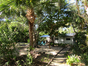 Grounds of the eco-village |
We checked in to our accommodation at Great Keppel Village, a low key eco-resort, to find out that we had been upgraded from a safari tent to a cabin for the first two nights - a pleasant surprise. The village was set in amongst the trees just back from the beauiful white sand of Fishermans Beach - it was a tranquil spot and we were looking forward to the next four days. |
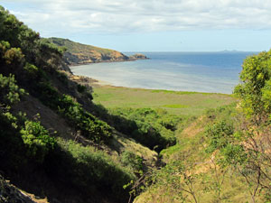
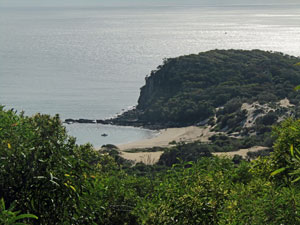
 Keppel Island coast |
Because of its size and diversity of landscape, Great Keppel is a great place for bushwalking, something we were looking forward to. It still has areas of close-to-shore reefs, so snorkelling remained high on the list of activities. In fact, with several beaches and reefs scattered between the rocky edges of the island, combining the two seemed the way to go. |
|

Monkey Bay Circuit (6.5 km - 160m ascent - 160m descent) |


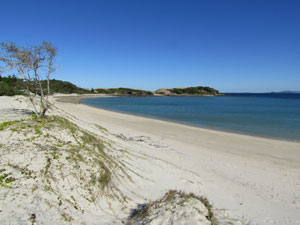
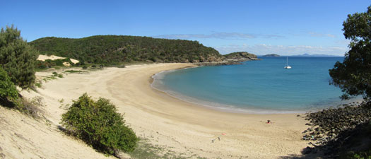
After an early lunch on our day of arrival, we decided to do a short circuit out to Monkey Beach from the village. Normally, when setting off on a bushwalk you don't pack flippers, mask and a snorkel, but hey this is Great Keppel Island. We set out to walk down the paved pathway of the village area and drop onto the broad white sand of Fishermans Beach. Across the channel the distant mountains of the mainland formed a blue ribbon on the horizon. Nearby, the much smaller Middle Island protected the north of this beautiful bay. |
 The sweeping curve of Fishermans Beach on Great Keppel Island |
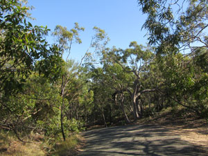
At the end of the beach, the track turned inland and soon came to a junction - we chose left to head outwards and upwards along a sandy 4WD track through a forest of eucalypts and casuarinas, the latter tinted orange with pollen. The track followed the ridge of a secondary sand dune, with glimpses out to the even higher rocky ridge of Mt Wyndham (at 175m, wishfully named as a mountain). |
||
 Casuarina-line track |
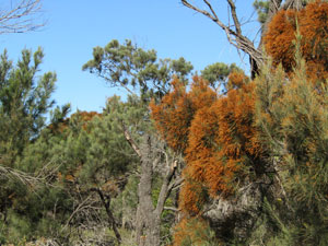 Casuarinas laden with orange pollen |
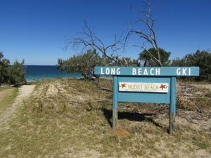 Entry to Long Beach (clothes optioanl apparently) |
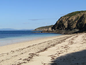
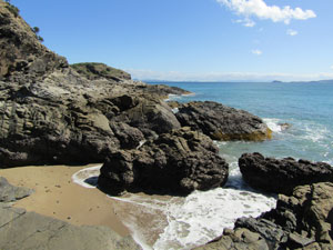
Soon after, the track descended quickly to spill out in the middle of Long Beach, on the south side of the island. Here we were exposed ot the prevailing south-easterly wind, cool but not unpleasantly so. We turned west to walk along the white sands and reach a narrow neck of rock jutting into the sea. the passage across was a sandy saddle that passed by a large aboriginal middens, dating back some 700 years. |
|
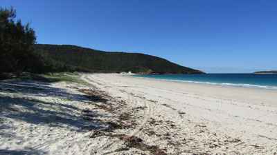 Looking south down Long Beach |
 Monkey Beach from the iddens saddle |
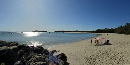
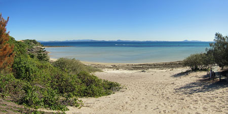
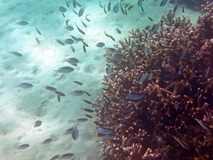
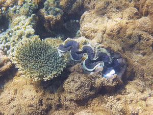
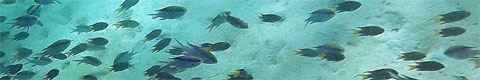
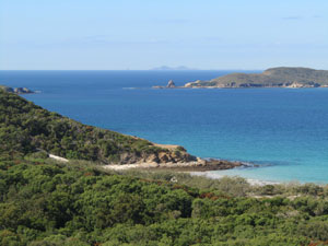
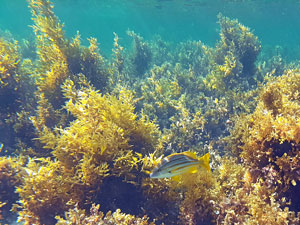
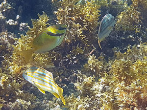
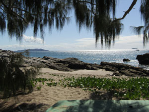
On the other side of the saddle lay our destination, Monkey Beach. What a beautiful panorama greeted us. Backed by low white dunes and forested slopes, Monkey Beach has clear blue water, fringed by the darker shape of a coral reef. Snorkelling this reef was possible from the beach. |
||
|
|
|

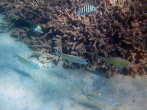

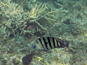
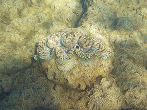
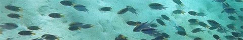
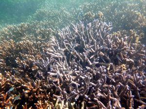
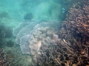
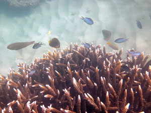
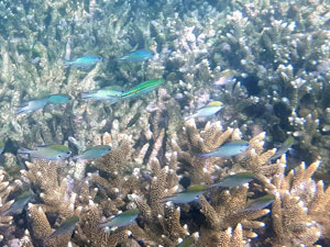
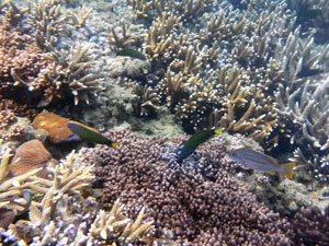
We had arrived about an hour after low-tide, the perfect time to access the reef and explore both its edges and its top. Stopping in the shade of a casuarina, we quickly switched from shorts and shirts to bathers and rash-tops, got out the snorkelling gear and headed out. The photos here will give an idea of the types of coral, fish and other sea life of the Monkey Bay Reef - it was great. |
||
 |
 |
 |
After finishing our brief exploration of the reef and getting back into warm and dry walking gear, we headed off. This time, we walked to the northen end of Monkey Beach to pick up a narrow and eroded track that climbed steeply up a rocky knob. It was a sharp climb beneath the drier forest of the knob, before finally descending more gradually to Fishermans Beach. Crossing the knob, we were given glimpses through the trees of the sea, the distant mainland and the shore of Great Keppel. |
||
 Crossing the rocky knob |
 View northwards from the knob |
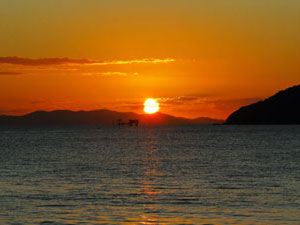
 A golden Keppel Island sunset |
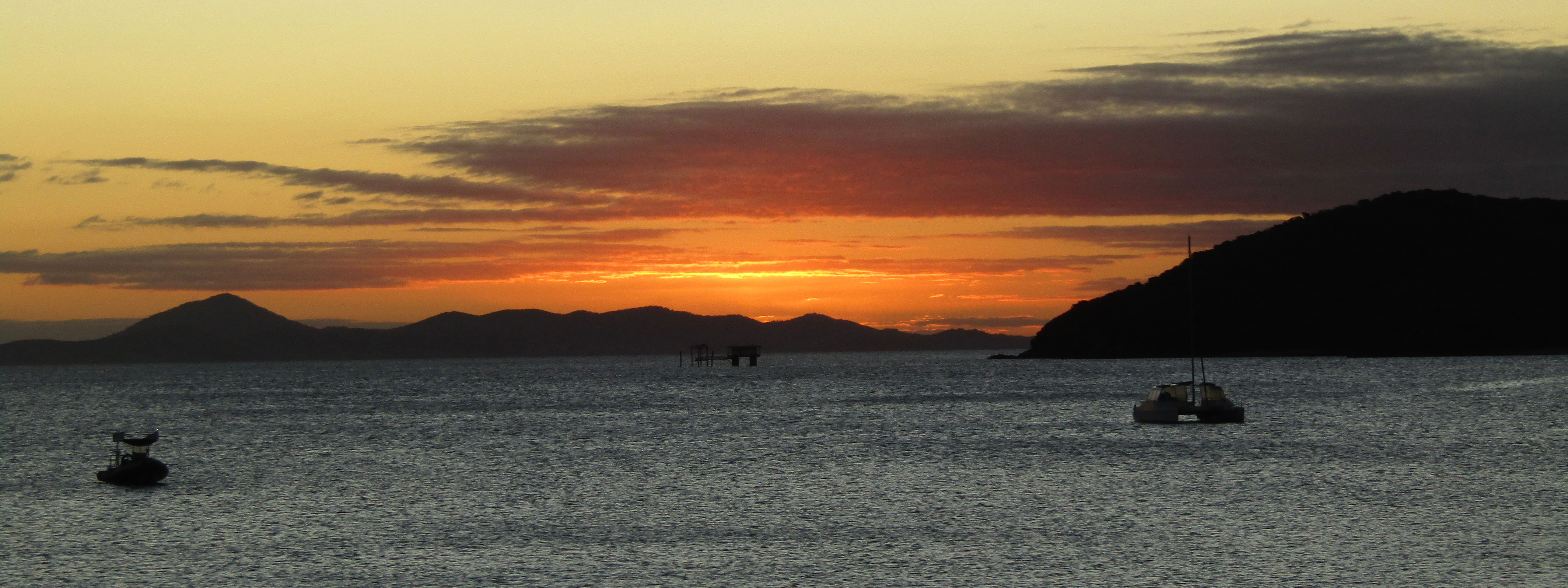
Finally, rejoining our outward path at the southern end of the beach, we had one more pleasant stroll along its protected southern end, blue water glistening in the sunlight. It was a great introduction to bushwalking on Great Keppel Island made even better as we took our cold beers down to Putney Beach to watch the sun set golden over the sea. |
|
Mt Wyndham Circuit plus Clam Beach (15 km - 330m ascent - 330m descent) |
With another clear blue day and temperatures in the low 20s, it was time to further explore Keppel Island - this time heading west to climb the high point of Great Keppel, 175m high Mt Wyndham. Unfortunately, I would be on my own, as the fair Nello woke with a painfully swollen calf muscle - no walking for her today. Rest in the lush grounds of our eco-village and on the white sands of the beach were prescribed (after calling in to the Yeppoon Hospital later as we were leaving, we found out that it was a burst Bakers Cyst in the back of her knee - you can check that out with Mr Google). The route to the summit started out by following an old asphalt road, in varying stages of decay. Passing some not so aesthetic abandoned construction sites and storage yards, the road began to climb steeply into more pleasant bushland. After a while it reached First Lookout - not all-round views but nice glimpses of the coastline to the north. |
||
 Old road up to the First Lookout |
 Open forest of the ridgetops |
 Mt Wyndham |
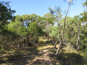
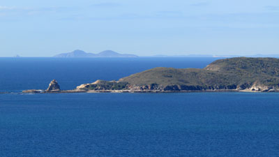
The old road dropped briefly to reach the point where a single file uneven foot track began the climb up to Wyndham. This was on a rocky ridge and the eucalypt forest was distinctly shorter and more scrubby. Reaching Second Lookout, I paused to look out over the shrubbery to the islands to the south of Great Keppel. The best view, however, was on the way down, where a wider panorama of the southern coast and offshore islets opened out. |
||
 View eastwards towards the distant mainland |
 The eastern coastline of Great Keppel |
|
Across to the west, on this same ridge lay Mt Wyndham. I descended quickly to the saddle from whence the final climb began. It was a two-tiered climb, a couple of short, steep uphill sections separated by a more gentle rise along the ridge and, finally by the more gentle summit ridge-line. I had reached the high point of the island and, to be honest, was a little disappointed with the views. As with Second Lookout, the only views were to the south, and the northern end of the island ws blocked by the scrubby summit trees. |
||
 Looking down from Mt Wyndham |
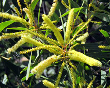
 Casuarinas heavy with orange pollen |
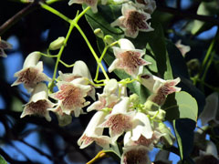
 The wattles of Mt Wyndham |
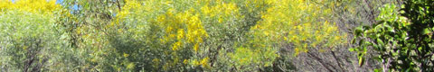
Descending the western flank of Mt Wyndham changed my mood. Here, on this windward flank, the vegetation was even more stunted. The track meandered down through thickets of coastal acacia, in full flower, and the sweet perfume of their rod shaped blossoms permeated the air. Occasionally, casuarinas, heavy with burnt-orange coloured pollen added to the mix. The bonus was that this slope was much more exposed and the vistas of the southern coast line opened out for the whole descent. |
||
 |
 Ocean view from the slope of Mt Wyndham |
 |
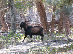
This track met up with the old 4WD road that led to Clam Bay. I turned and followed it beneath the shady canopy of the taller sand-dune forest. Eventually, I reached a point where the track turned inland to follow the old-dune side of a creek, descending through taller casuarinas and eucalypts. When the track ended, a footpath continued to climb up and over the primary dunes. At times the track almost disappeared, due to blockages by fallen trees, before reaching a deep and heavily eroded gully. It was the route to the beach and also the route for a couple of feral goats that watched me pass by. |
||
 Lowland forest |
 |
 Being watched by a feral goat |
 Route down the erosion gully to Clam Bay |
The gully emerged into a tangle of vines, which made for an interesting last 100m before emerging on to the beach at Clam Bay. The tide was out, so I turned east and wandered along the beach beneath some rugged cliffs to its end. This was apparently the end to snorkel, so I unpacked the gear and swam in. Perhaps it was because the tide was too low to reach the good part of the reef, but Clam Bay was no Monkey Beach. Here, much of the reef that I saw had waving fronds of sea-weed, with but a few fish. It was different and pretty in its own right, but still the lack of coral was a little on the disappointing side. |
 the beach at Clam Bay |
 |
 Snorkelling the seaweed bed of Clam Bay |
 |
After a snorkel and lunch, I retraced my steps through the vines, up the gully, past the fallen timber and along the old road. At the Mt Wyndham junction, I kept going eastward into new ground. It was pleasant and shady walking in this longish inter-dune valley with its taller trees. A break in the native vegetation and a grassy paddock marked the site of the old island homestead. It was hard to believe that people once grazed sheep here, though the flock of feral goats certainly likes this spot. |
||
 Casuarina forest in the sandy valley |
 |
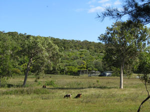 Open paddock near the old homestead |
From the homestead, I chose to head along the road to Leekes Beach, rather than climb the steep ridge back to First Lookout, and rounded an area of flat clay pan labelled on the map as "wetlands". |
||
 The old Keppel Homestead |
 Track across the flatlands |
 Clay pan behind Leekes Beach |
Emerging onto Leekes Beach was a lift for the spirits after a long walk back. With its sweeping stretch of white sand and the sun glistening on a calm sea, it is indeed a beautiful part of the island. |
||
 Arrival at Leekes Beach ... |
 ... with its long wide stretch of sand |
 Yt another golden sunset |
All that was left now was a long stroll down the low-tide sands of the beach, a short climb over the ridge separating it from Putneys Beach and a final stroll along the edge of Putneys Beach to the village and home to complete the circuit. The fair Nello was wating at the southern end of Putneys Beach to limp home with me and learn all about the interior of Great Keppel Island. |
|

Butterfish Bay Circuit (14 km - 310m ascent - 310m descent) |
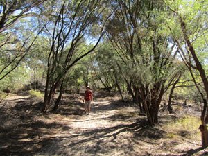
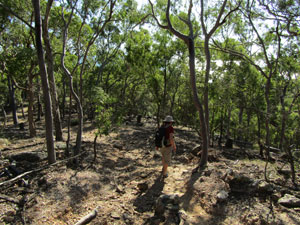
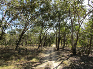
Having headed west yesterday, it was time to head north to explore a different part of Great Keppel Island - the target Butterfish Bay, famed for the clarity of its water and its small coral reef. Unfortunately, the fair Nello's swollen calf was still giving her grief, so this would be another solo effort. There was a bit more cloud in the sky as I set out, repeating the track of yesterday up to the First Lookout. From here I descended, but instead of taking the footpath that led to Mt Wyndham, continued on the old road to make a steep descent on plate rock slabs to the edge of the Wetlands. For a short time I followed the Wetlands around, passing Great Keppel homestead for the second time. However, at the Clam Bay junction, I continued on into new territory. It was pleasant walking in this lowland forest, crossing Blackall Creek to follow the road up a low rocky spur. |
||
 Road crossing the lowland forest |
 Looking back towards Leekes Beach |
 The highland forest of Great Keppel's centre |
At the saddle, a steep and loose rocky path split off to head directly up the spur. I was now climbing the central ridge-line of the island - a hot and sweaty climb up the shaly rock, but one which offered occasional superb views through the trees of the valley to the west and Mt Wyndham, or behind over the eastern coastline. |
||
 Ridge-top vegetation |
|
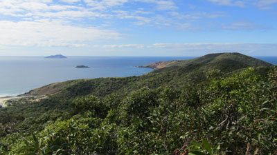 Panorama of the northern end of th island |

At the high point of the ridge the track split again, right to head out to the lighthouse, left to head to Butterfish Bay - I turned left. The cool breeze blowing across the ridge soon dissipated the sweatiness of the climb and, as the track undulated northwards along the ridge, views appeared both to the west over Wreck Bay and the peninsula bearing the lighthouse and east over Leekes Beach and the yachts moored in the lee side of the island near Second Beach. |
||
 Track descending from the central ridge |
 View out over Second Bay |
 View towards Butterfish Bay |
Not long after, the track began to descend the end spur, with views down to Butterfish Bay and its backing dunes. Soon after, I turned east onto the Wreck Bay Track, quickly descending the flank of the rocky spur to reach the sand dune area. Here, a left turn took me in the direction of Butterfish Bay to arrive at the top of the large exposed dunes that back it. |
|
 The solitary cabbage palm |
 Panorama of Butterfish Bay |
|
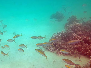
It was mid-tide, a good time to snorkel. Butterfish Bay has a superb setting, its curving white sand beach locked in by rocky promontories at each end and backed by large dunes. I walked to the eastern end which held the reef area and, after a brief rest to take in the scene, got out the snorkelling gear for an explore. Unfortunately, the below water scenery did not match that above water. A lot of the reef was dead and crumbling, and large areas were a forest of staghorn corals with little else. Some patches of soft corals added interest, but I didn't stay too long. Time to start heading back. |
|
 |
 Snorkelling a small patch of coral in Butterfish Bay |
 |
Not wanting to reclimb the ridge, I took advantage of the low tide to walk to the western end of the beach and pick my way around the jagged rocks at the base of the promontory. This was good fun, but with deep channels cutting in to the rocks, it is definitely a low tide route. |
||
 Leaving Butterfish Bay |
 Rocky coast on the north shore of Great Keppel |
 Lunchspot on the Little Peninsula |
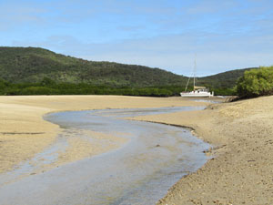
The rock walk brought me out on to a tiny sandy beach at the northern end of Little Peninsula. Someone had set up a table and chairs in the shade of a casuarina with views out towards North Keppel Island - it was the perfect place for lunch, thank you. From my lunch spot, I crossed over to Svendsens Beach to be greeted by the sight of a flotilla of moored yachts and catamarans - this is definitely the lee side of the island. |
||
 |
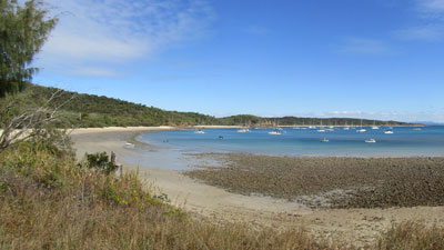 Yachts moored off Second Beach |
|
|
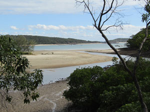
A track off the beach led to the main route south, an old 4WD track that followed the shoreline beneath the lowland forest. Climbing was not completely over, as it crossed a low spur to pass from Svendsens Beach to Second Beach and then a higher spur to pass from Second Beach to the Wetlands. Here a small side track led towards the coast, skirting the mangroves to reach the edge of Leekes Creek. Again, with the advantage of the low tide, it was easy to wade across the creek, though first passing through a section of sticky mud flats. This brought me to the northern end of Leekes Beach. |
|
 Channel in the Wetlands
A long stroll down the firm low-tide sand of the beach, a bit of bushbashing to cross the rocky spur at its southern end (attempting to find a second marked route, which I suspect has disappeared) and a brief look at the mangrove flats in Putneys Creek brought me back to the Village - circuit completed. This was an excellent walk, with a good diversity of landscapes. |
||
 Tides out at Leekes Beach |
 |
 Mangrove swamp at Putneys Creek |
With only one day left here, I think it is time to relax a bit - maybe a bit is snorkelling at nearby Shelving Beach (people say it is good), a swim in the clear waters of Fishermans Beach and a good bit of time lazing about - after all, as the fair Nello says, this is meant to be a holiday. |
||
|
|
|


FOOTNOTE: The fair Nello's swollen and painful calf was not getting any better, so, on returning from Great Keppel, we went to Yeppoon Hospital, where they did a Doppler scan. The diagnosis was a ruptured Bakers Cyst, which was now leaking fluid down into her calf muscle and ankle - very unpleasant. Not much can be done about this, apart from RICE (rest, ice, compression, elevation) until the fluid is reabsorbed by the body (much like a very bad bruise). |
|


