| On the Lycian Way |
The Lycian Way is Turkey's first long-distance walking track, following the shoreline and coastal mountains for over 500km from Ovacik, near Fethiye, in the west to Hisarçandir, near Antalya, in the east. In doing so, it follows the bulge in the Anatolian coastline that defines the ancient region of Lycia. It is in fact the passage of past civilisations that sets this walk apart from any others. Not only are there ruggedly beautiful land- and sea-scapes, but the ruins of ancient cities and traces of their people. The track was pioneered by Kate Clow, who has done an enormous amount to help the development and promotion of trekking in Turkey. It was opened in 1994 and has rapidly become one of the great walks of the world. |
|
|
 The old fort in Kaleiçi |
|
|
The minibus took us, two French people and a Turkish guide westward from Antalya. We were doing the self-guided walk along sections of the last part of the Lycian Way and they were doing a very similar guided walk with their French-speaking guide, Ali. We all headed out along the extremely rugged Lycian coastline, through a series of tunnels bored beneath the rocky mountains that butt right up to the sea, to the starting point of our 5-day trekking sampler of the Lycian Way. It was an inauspicious starting point, a pullover alongside the main road, where a red and white marker indicated where the Lycian Way crossed over on its final push inland. We were however heading in the opposite direction towards the coast. |
|||
 Starting down the track on The Lycian Way |
Bringing up memories of our blue cruise misadventures, we discovered that the trekking company had forgotten to include our walking guide notes with our packed lunch, which to a large extent defeated the purpose of doing a self-guided walk. The solution was for us to join Philipe-Alain, Marie-Claude and Ali on a guided walk. Since arriving here, we have learned to take it as it comes, so off we set - the trip promised to be interesting and our French-speaking skills were about to get an unexpected workout. |
||
 |
 |
 After a short walk we reached the Mediterranean coast |
|
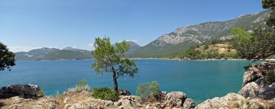
We found ourselves on a narrow dirt road, which led us quickly through the scrubby pine forest to a sparkling bay – the classic Mediterranean landscape of blue seas, rocky shores and pines. Crossing a small beach of smooth rounded white pebbles, Ali led us up onto a rocky pine-covered headland. We appreciated the shady canopy as we crossed the headland to reach its western side. |
 View down the cliff line to Mt Olympos (2365m) |
||
 Taking time to admire the seascape |
 |
 |
|
Looking north, a line of orange cliffs directed our gaze up to the imposing blue silhouette of 2365m Tahtali Dağ (aka the eastern Olympos), a mountain revered by the ancients. With large white clouds billowing about its summit, it was easy to see why. |
|||
We resumed our path beneath the pines, passing through an ancient necropolis – the broken slabs of 2000 year-old tombs scattered amongst the rocky outcrops and scrubby understorey. The track dropped down onto a rocky shoreline and we followed the narrow path between sea and low-cliff into a wide bay. Ahead lay some more impressive upright tombs (for the Lycian A-list), plus remnants of a stone wall, buildings and an arched aqueduct. We had reached the site of the ancient city of Phaselis and it was time for lunch. |
|||
 In the shade of the coastal pine forest |
 2000-year old Lycian graves in the forest |
 An upright tomb near the shore |
 The ancient aqueduct of Phaselis |
 How to pass the heat of the day No. 1 |
Phaselis was founded in the 6th century BC and was variously ruled by Lycians, pirates, Greeks, Persians, Romans, Arabs and Byzantines before passing into oblivion by the 13th century. Learning the history of this city was one of the advantages of walking with a guide and we could not fault our classroom of old stones walls in a soft brown bed of pine needles.
|
The sun was reaching its peak, so we took a break sitting in the shade of the pines on the edge of a small bay, listening to the wind sighing gently in the canopy above and imagining the fisherman coming in to port and landing their catch on the stone steps opposite, all those centuries ago. Our reveries over, we headed on to wander through the ruins of Phaselis where Ali showed us the old bath houses, market places and 3,000 seat amphitheatre – fascinating. |
|
 View over the ruins of Phaselis |
|
 The amphitheatre of Phaselis |
 Looking out over the main shipping harbour of Phaselis |
|
 The beauty of the coastal Taurus Mountains |
|
 Inlet near Tekirova |
|
|
The morning dawned clear and blue with the sun already indicating that it planned a hot time for our second day on the Lycian Way. After a short transfer by car from our pension, our little band of 5 found ourselves once again on the side of the road where the Lycian Way crossed it. This time it was our turn to head inland, following a 4WD road up into the pine forest. |
 Mosque on the Mediterranean Coast |
 Mt Olympos revealed |
 On the road again |
The rhythm for the day was soon set, as the wide stony track meandered and undulated its way across the pine-covered spurs and valleys running perpendicular to the coast. Although summer was almost here, there was still an abundance of wildflowers scattered along the edge of the road, enough to keep my camera clicking over and ensure that I was permanently in the rear. |
||
 |
 |
 |
 |
 |
 |
|
 Looking out over Kara Bay and Chrome Beach |
||
 |
 |
 Insect camouflage 1 - find the adult ant-lion |
 |
From on high, we overlooked a series of beautiful little coves and inlets, while beyond the bright bare summit of Olympos appeared, vanished and reappeared as we passed from ridge to valley to ridge again. This was a very picturesque section of coastline. At a couple of points, we dropped down to cross the flats at the rear of the grey-brown gravelly beaches, grasslands dotted with flowering herbs and scatterings of the ubiquitous pine. Finally we reached the saddle and, from just beyond it, caught the first glimpse of Çirali beach, our goal at the end of the day. |
|||
 Rugged coast line heading toward Musa Daği (Moses Mountain) |
 |
 The dry interior of the coastal hills |
The descent was rapid at first and we quickly found ourselves next to the diggings of an old chromium mine that overlooked the drier mountains further inland. The road then took us out along a long spur before dropping down to the large, brown-sand beach of Maden Beach. Here also were the ruins of the mining operation and port, abandoned in the 1960s, and a small fish-farm. The floating cages, however, were all piled on the beach along with the flotsam and jetsam of this aquaculture operation – it was the first bit of ugliness we had seen on the walk. We hurried by in the soft brown sand to a rocky footpath that climbed shortly and sharply over a scrubby ridge to drop down to a more isolated brown pebble beach on its far side. After 4.5 hours of walking we had reached our lunch / siesta spot. |
 Now that looks like a good lunch spot |
 How to pass the heat of the day No. 2 |
There was a small uninhabited fisherman’s camp there and we were met by two dogs and rooster. The former two were friendly enough – in fact they wanted to join us for lunch in the shade of pines filled with the summer drone of cicadas. It was a time to laze and read and swim in the curiously stratified water of the bay – tepid on the surface and chilly cold near the bottom. We spent a lot of time diving down to the refreshingly cold deep layer. |
|
 Our siesta companion |
 Looking back on our lunchtime swimming beach |
|
 No, not pirates - just a gulet full of tourists |
At 3pm, with the temperature still well into the 30s, we set out on our final push to Çirali. The rocky path climbed up the headland on the far side of the beach, offering great views back over our lunch spot and the coast beyond, before descending a set of zig-zags into a deep and spectacular ravine.
|
 Descending into the ravine |
At the bottom of the ravine, we followed a dry creek bed back out to an isolated brown-sand beach on the far side of the bay. From here, the climb began all over again, as we undulated and meandered around the steep pine-covered slopes, between 20 and 120m above the deep blue sea. |
||
|
 The grey brown sand of an isolated beach |
|
It was a beautiful section of coastline, but I was finding the going unexpectedly tough in the hot sun – sugar deficit was setting in, so I had to call a rest stop to get a boost from some lollies and a drink of rehydration salts (which every trekker should carry). With a quick sugar boost, it only took 10 minutes to recuperate, cross the last two spurs and look down on the broad light sand beach of Çirali, backed by the brooding peak of Musa Daği – a superb and welcome sight. |
 Çirali Beach backed by Musa Daği (Moses Mountain) |
|
 Crossing the mouth of a dry creek |
 Distant Olympos overlooks a secluded cove on the Lycian Coast |
|
We descended the stony footpath quickly to reach the flat plain backing the beach and a short walk along the road brought us to our pension and bed for the night. Our clothes were absolutely saturated with perspiration - never has a cold beer tasted so good nor a shower felt so soothing! It had been a long day’s walk and a hard one, not because the route was particularly difficult, but because of the heat. A suspicion was developing that the Lycian Way is best walked before the heat of summer starts to set in.
|
After loading our packs up with extra water, we set off to follow the main road of Çirali, as it ran parallel to the beach past a long line of pensions and hotels. Near its western end, we cut on to the white-grey pebbly beach to continue heading west towards the towering face of 982m Musa Daği (Moses Mountain) and a low rocky cliff near the end of the beach with several ruined walls. We had reached the entry to Olympos, one of the six major cities of the ancient Lycian League. |
|
 Heading along Çirali Beach towards Musa Daği and the ruins of Olympos |
 The lagoon at the entrance to Olympos |
The entry to the city site was spectacular – rounding the cliffs we looked up a deep river valley, lined on both sides with dense and lush broadleaf vegetation. In front lay a shallow lagoon, full of croaking frogs – all that remained of the silted up harbour of the ancient city – while on either side of the river were the scattered remains of the cities buildings, dating from the 2nd century BC. Ali told us about the history of Olympos, and led us past the monumental tombs, along the ancient water canal, past the ruins of Roman temples and Byzantine bishop’s houses, all witnesses to Olympos’ long and diverse history. The cool shade of the jungle-like vegetation provided welcome relief from the sun, already hot at 10am. |
|||
|
 Following an ancient water canal |
 Remains of a mosaic floor |
|
|
|||
Leaving the ruins of Olympos, we passed through the modern tourist village of the same name, a haphazard collection of wooden cabins, bars and self-styled treehouses (usually just huts on stilts). This is another place on the backpacker circuit for pretend-hippies and we hurried through, turning off the road to follow a dry, boulder-filled creek bed out past the plastic bottles and refuse of modern Olympos (Gaia would not be pleased). Crossing the creek, we followed a footpath to start a 200m climb on a long traverse through the pines lining the steep valley walls. After the deep shade of ancient Olympos, the pines seemed to offer little protection from the sun, and with the temperature well into the 30s, we were once again feeling the heat stress of yesterday. |
|||
 Grassy clearing near Omurga Dağ |
 |
 |
 Insect camouflage 2 - find the katydid |
 |
|
 |
 Pomegranate orchards of Sarmasik Mahallesi |
 |
 Silver-leafed olives framing distant Mt Olympos |
|
||
 |
 How to pass the heat of the day No. 3 |
 |
By the time we set off again, some high cloud had built up and the temperature fell to around 30. It was bit more pleasant as we quickly left the paved road to ford a stream and then follow it around into a cool valley. Passing an old watermill, now turned into a rainbow-coloured residence by its friendly alternately-oriented owners, we started a steady climb up through the pines along a churned up forestry track. The valley narrowed and the road followed the edge of a small rocky gorge - the sound of unseen water cascading down it drifted up from below. As the gorge widened, we dropped down a steep bank to rock-hop across the stream and pick up a goat track on the far side. We knew it was a goat track because we passed the old goat herd and his bleating flock as we crossed the mouth of a narrow rock-walled side gorge. |
|
|
|
After a short break during which the fair Nello made friends with a tortoise, we started the long descent of stone steps used by the ancients to access their temple and the eternal flames. We had just left in time, as we passed four busloads of hot and red-faced Russian tourists clambering up the steep steps to visit the site. It may sound a bit selfish, but it was a different experience to enjoy it on our own than with a hundred or more other members of the human race. |
 The ancient stone path to the Chimaera |
|
 ....burning for thousands of years |
 The fair Nello's new friend |
|
|
The stable weather pattern seemed to be hanging around, which meant another hot day on the Lycian Way. The bad news was that today we faced a climb of over 700m – the good news was that it would almost all be in the shade. Setting out from the pension, we quickly retraced our steps of yesterday down the road and along the crunchy pebble beach to reach the entrance to Olympos again. |
||
 L'equipe FAT (Franco-Australo-Turque) sur la plage de Çirali |
 |
 View back over the entrance to Olympos Creek |
However, this time we took off our boots and waded across the shallow river mouth. Once on the other side, we found a footpath into the dense undergrowth on the western bank of Olympos and followed it past a series of ruins overgrown by the thick vegetation - Lycian tombs, Roman baths and amphitheatre, Greek walls – all adding to the colourful history of the site. |
|||
 The Roman baths of Olympos |
 Trees invading the ruins à la Angkor Wat |
 An arched passage way |
 Tomb in the south necropolis |
After passing a series of tombs, we reached the end of the city and the start of a very long climb. The Lycian Way was about to follow the ancient route from Olympos to Phoinikous, some 700m higher and a place where the residents went to escape the summer heat. We had the same idea! The track climbed steeply at first, past more tombs in the old necropolis, before eventually leaving the ruins to traverse around a heavily wooded slope and into a deep valley leading towards the massif of Musa Daği. |
|||
|
|
|
One last push brought us out to the clearing on top of the pass, where we were greeted by cool and refreshing westerly wind – it was as if someone had opened the fridge door. A little higher up to our left lay some of the jumbled ruins of ancient Phoinikous – with the cooling wind sweeping across, it was clear why they had chosen this site for a summer retreat. |
||
 Crossing the drier high slopes of Musa Daği |
 The ruins of Phoinikous hidden in a pine grove |
 How to pass the heat of the day no. 4 |
After spending a bit of time at the pass, we made a short descent on a forestry road to reach a dilapidated shepherd’s hut, surrounded by some large pines. Far down lay a broad green valley, covered with a mosaic of glasshouses and orchards. With the wind rushing though the shady pines, it was the ideal place for lunch and the, by now, compulsory siesta. |
 Meditation on a Lycian landscape |
|
 View over Çavusköy village and valley |
 A pair of vultures riding the thermals |
|
The climbing was over and the long 700m descent was about to begin. With our sweat-soaked clothing dried by the wind, we followed a forestry road around the tops to a second saddle, where the Lycian Way transformed back into a footpath that started to drop down the next valley. The descent became increasingly steep as we followed the valley down, watching it transform gradually into a deep pine-filled ravine, lined by grey rock walls. The track switched from side to side of the ravine, crossing the dry boulder-strewn stream bed twice, as it brought us quickly out of the ravine to a patch of dried-off pasture. Just as quickly, we re-entered the forest to follow the stream heading toward the coast beneath a line of orange-coloured cliffs. |
|||
 Tthe rich forest below Musa Daği |
 Sunlit pines in the ravine |
 Looking back up the ravine |
 A tight squeeze |
 Crossing a field of dry grass - summer kicks in |
 Cliffs at the back of Adrasan |
||
A quick scramble down through a jumble of large boulders and rock outcrops brought us to the valley flats of Adrasan. From here, it was just a longish trudge through the glasshouses, orange groves and pomegranate orchards to reach our pension in the village. The pension held one last surprise for our walk – it was situated right next to a broad but very shallow stream, now contained by stone walls, but with tables and chairs sitting out on mini-piered decking in the middle of the stream. |
|||
 Pomegranate orchard near Adrasan |
 |
 Final dinner with our friends at Adrasan |
Our riverside pension was a great spot to cool down with the obligatory Efes and to enjoy one last dinner with our companions de route. Tomorrow, Ali was taking our French friends in a different direction and we were finally going to do a self-guided section of the Lycian Way. Let’s hope that the change which seemed to start blowing through as we arrived at the pension would bring us cooler weather. |
||
  |
It was sad to farewell Marie-Claude, Philipe-Alain and Ali, our companions de route of the last few days, but we were also looking forward to walking to our own rhythm today. We had learnt a lot walking with a guide, but we pace ourselves very differently. Over the years you get to know your body and today there would more short stops, perhaps just to listen to the wind, perhaps to sit and admire a particular landscape, to investigate some wildflowers or because we were just plain buggered. More frequent stops and a shorter lunch break – it’s just the way our walking has developed. |
 Up a creek - both literally and figuratively |
|
 Approach to the saddle of Kizil Sirti |
A little more warily, we followed it through the pines as it climbed up a valley, zig-zagging as we got higher to reach the pass between the summits of Kizil Sirti and Talik Burun from where we could look out through the trees to the blue on blue horizon of the Mediterranean. From here the walk would keep the sea on our left and the rocky ramparts of Cape Gelidonia on our right. The track now took us on a gentle downward traverse in the shade of the pines. When we reached the rocky red knob of Gavurnaman Tepe, we took off our packs to clamber up it for a spectacular view of the rugged eastern face of the cape. The narrow finger of land that formed the southern end of Kelechi Bay pointed out towards the pyramid shaped island of Sulu Ada – spectacular. |
|
 Panorama from Gavurnaman Tepe |
 Close up of Sulu Ada |
 Now where is that track? |
From here the track continued its gradual descent – we picked our way across an area of boulder scree to reach the low point of this section at 115m, just above Kelechi Bay. Apparently there is a side track here that descends to the bay and the idea of a swim was very tempting, but in this weather we weren’t prepared to give up 115m of height for anything, especially as the main climb of the day was about to begin.
|
 Rugged landscape of the peninsula |
We started upwards, crossing a dry creek bed and continuing up a set of long zig-zags that brought us quickly to the top of a steep pine-covered slope. From here, we headed due south, losing some of the precious height, before following the 200m contour around, passing out of the pines, with their low shrubby understorey, to a dry grassy area with a scattering of stunted oaks. As the canopy opened up, we could look up to the sheer rock cliffs running down the spine of the cape above us. |
 Looking straight down onto a tiny inlet |
|
 The cliff-line of the Gelidonia range |
 A fellow user of the track |
|
Vistas also opened up towards the sea, looking down on tiny clear green-blue inlets below or watching the changing shape of Sulu Ada, as the true elongated form of the island became apparent. Eventually we reached a point where the cliffs closed in on the sea and the track began another steep climb upwards through jagged rocks and low scrub to the 400m contour. Here our climbing for the day ended – the track traversed the slope on an even southward course, a thin ribbon of reddish earth and stones running through the grey boulders and low green scrub. The pines were becoming more stunted as we approached the more exposed end of the cape. The islands to its south began to appear one by one as we reached the line of the spur and started to descend, until finally the lighthouse itself appeared through the greenery. The last bit of the descent was steep and tortuous as we picked our way down though the low jagged rocks until we finally reached the lighthouse, its white buildings and tower framed by Beş Adalar (the Five Islands) offshore to the south – one of the more spectacular lighthouse settings. |
||
 Looking back over the track route along the eastern shore of Gelidonia |
 |
 The red clay track winding through scrubby pine and oak |
Finding a flat wooden platform in the shade of an olive tree, and with a light cooling breeze blowing in from the sea and the steady chirping of cicadas drifting down from the trees, we declared a lunch break. Over the past four days we had got into the habit of long lunchtime siestas and it was tempting to do the same today. However, along with mad dogs and Englishmen, we set off into the midday sun. |
 Descending the old lighthouse keeper's track |
||
 Gelidonia Lighthouse (built in 1936) and the Five Islands |
 |
 |
|
The sign said 8 km to Karaöz and we were keen to get there. It was actually quite shady at first as we descended from the lighthouse along the broad lighthouse keeper’s access track to gradually merge with a road below, heading north along the western side of the cape. With the sun on our backs we pushed quickly down the road, beneath the sheer walls of Gelidonia’s mountainous spine towards the cliffs of Melanippe, plunging spectacularly into the blue Mediterranean. |
 Cliffs on the western side of Gelidonia |
|
 Western shoreline of the Gelidonia Peninsula |
 |
|
 All that remains of ancient Melanippe |
Passing some small agricultural enterprises, we turned toward the sea to stop at a small and calm cove tucked into the surrounding sea-cliffs. Scattered around us were a few jumbled ruins, all that remained of the ancient city of Melanippe, hidden away from the looting eyes of passing pirates. The bay around from Melanippe was a spectacular turquoise colour, and framed by the rocky towers of the Gelidonia Mountains – one of the best coastal panoramas of the past five days.
|
Having skirted the bay on a pleasant footpath, we returned again to the road for the last 2km walk into Karaöz. The easy walking on this western side of the cape was very different from the rough footpath and steep climbs of the eastern side. Reaching Karaöz, we walked quickly to the Lykia Restaurant, where our walk ended, to await our transport back to the pension at Adrasan - time to swing gently in a hammock, watching the parapentists drifting silently down from the heights of Talik Burun. Life can be hard sometimes. |
||
 A perfect day on the Lycian Way |
 |
 Waiting at Karaöz |
That night, we celebrated the end of our time on the Lycian Way by sitting out on the beach at Adrasan watching the flickering lights of moored boats and the moon shadows dancing on the white pebble beach. It had been a tough but enjoyable week and the Mediterranean part of our time in Turkey was now over. |
 Full moon over the old mosque in Kaleiçi |
|
 The obligatory end of walk glass of Efes |
 Moonlight on Adrasan Beach |
|
|
||