
| Day-Walks around Blackheath |
Prologue |
Blackheath is one of a string of towns stretched along the the top of a sandstone escarpment that forms the heart of the Blue Mountains. Cut by deep cliff-lined valleys, this region of lush forest, streams, waterfalls and eroded rock formations is a mecca for bushwalkers in Australia. Sadly, though, the horrific bushfires of the summer of 2020-21 devastated much of this region. Around Blackheath, valleys to the north were scorched, while those to the south remained relatively unscathed. Lorraine, from the Canberra Bushwalking Club, organised a week of day-walking from a base in Blackheath during November 2020. It provided an opportunity to see how the region had recovered 10 months after the fires on one part and to remind ourselves how fortunate we were that we could still wander through unburnt areas of this landscape and appreciate the beauty that has attracted walkers to the Blue Mountains for more than a century. Thus we found ourselves in the pleasant surrounds of Blackheath Glen Tourist Park, getting to know our fellow walkers and preparing for a series of day-walks that would take in the highlights of the area. |
|


Pierces Pass to Victoria Falls (11 km - 310m ascent - 290m descenor |

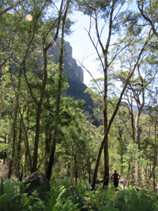
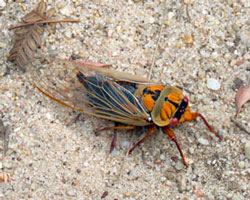
Sometimes it is not possible to do a circuit walk and, when a walk starts at one point and ends at another, a car shuffle is often the only way to get people back to the place where they have left their vehicles. Such was the case with today's walk, which started on the northern rim of the Grose River Valley and ended on its southern rim .... a few km as the crow flies, 11 km as the bushwalker walks and 30 km as the car drives. The car shuttle was the most difficult part of the organisation, but we ended up at a little past 9am, with one car at the end and four plus 13 walkers at the Pierces Pass Picnic area, where we set out on our walk. Blue Mountains walking often involves starting with a long descent into a canyon or deep valley and ending with an equally steep climb out, and this walk was no exception. We were in a small patch of forest that had been spared the flames of the bushfires 10 months earlier, and it was pleasant to start the descent in the shade of its canopy. Around us the cicadas were in full song, heralding the arrival of warmer weather. |
 |
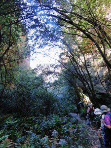
 Descent from Pierces Pass |
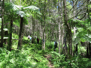
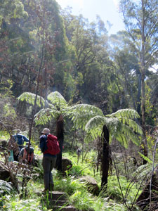
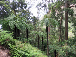
The well-formed and stepped path took us down into the narrowing side-valley of Pierces Creek and we soon found ourselves wandering beneath the dark shade of temperate rain forest trees, alongside moss-covered rock walls and next to the babbling stream. It was a pleasant place to be. |
|
 |
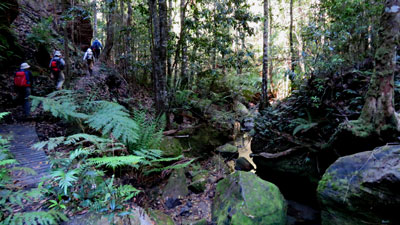 Rainforest deep in the gully of Pierces Creek |
|
|
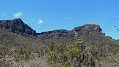
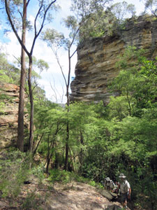
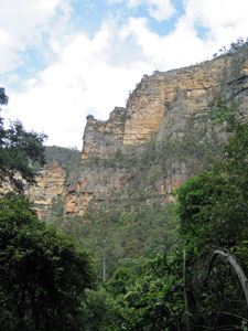
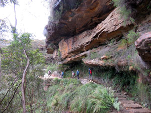
All too quickly we reached the point where the giant sandstone ramparts of Liversidge Hill and Rigby Hill guarded the entrance of the this side-valley. The creek tumbled away below us and we began to traverse the drier spur below the sandstone cliffs. Here, the fires had made their mark and many trees were showing blackened bark and a green fringe of epicormic shoots on their trunks. |
|
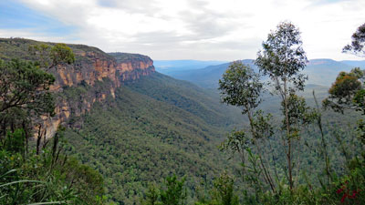
 Crossing the steep slopes below the cliffs |
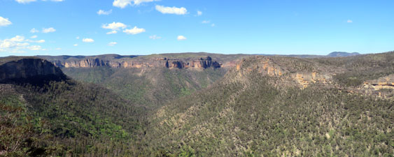
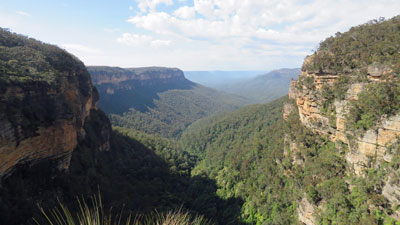
 Looking across to Burramoko Head and Burra Korain Head |
|

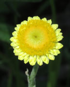
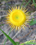
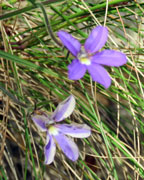
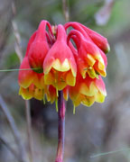
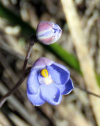
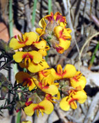
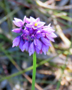
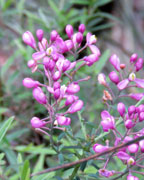
The forest floor was a mass of new green shrubs, ferns and herbs, with the bright red and yellow flowers of the Christmas lilies brightening the way. The scars of the fire were everywhere, but so was the evidence of post-fire recovery. |
|||||
 |
 |
 |
 |
 |
 |
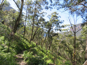
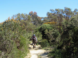
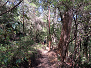
 Walking beneath unburnt forest |
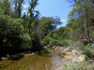
The track wound down the steep wooded spur below the cliff line, eventually bringing us to the bottom of the valley and the Grose River, a babbling boulder-strewn stream of sparkling clear water. Picking our way across a jumble of rocks, we reached its southern flank to follow a less-formed foot-track upstream. Here the babbling of the river almost drowned out the throbbing rhythm of the cicada choir.
|
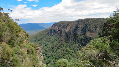
 Grose Valley riverscape |

 Wandering along the river's edge .... |
 .... across the regenerating slopes ... |
 .... and back to the river |
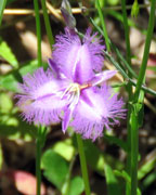
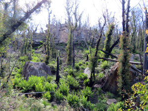
Above us the, southern slopes of the Grose Valley had been badly scorched ... the tops of trees remained blackened skeletons and the canopy had all but vanished. However, the soft fuzz of epicormic growth promised that one day it would return and, in the meanwhile, the open sunlight reaching the forest floor was creating a dense carpet of competing shrubs, grasses and herbs. The greenness of this emergent understorey was intense and was speckled with the blue, purple, yellow and white of wildflowers. |
||
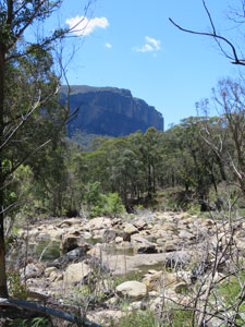 A boulder bed in the Grose River |
 Eucalypts regenerating after the fires |
 Skirting the mouth of Victoria Creek |
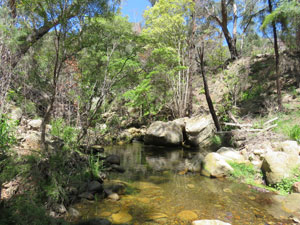
After a long traverse along the steep slope above the boulder-strewn Grose River, looked down on by its sandstone ramparts, we reached its junction with Victoria Creek. It was a good place for a rest and bite of lunch, as our clothes were getting a bit sweat-soaked in the still warm air in the valley. |
||
 Heading up the Victoria Creek valley .... |
 ...past clear rock pools .... |
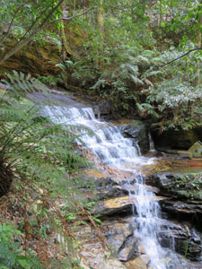
 .... and tinkling cascades |
|
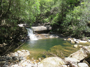
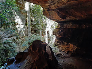
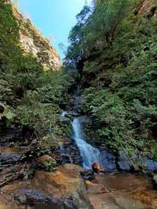
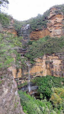
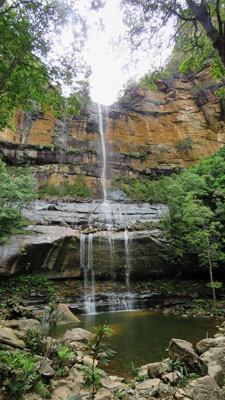
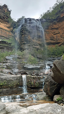
Then, it was time to follow the narrow track up the increasingly enclosed gully down which the waters of Victoria Creek were tumbling. Passing one small waterfall and a wide set of cascades, we reached our goal. Opening out in through the trees above us lay Victoria Falls. Here, the clear water tumbled down in two drops separated by massive overhanging rock shelf ... the latter 30m fall forming a sparkling curtain in the afternoon sun. |
|
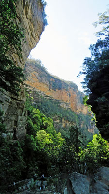
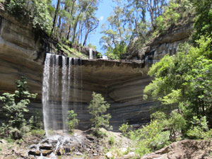 The wide rock overhang that splits the falls |
 Victoria Cascades |
|
It was a good place to relax and enjoy the beauty of the Blue Mountains landscapes, along with the smaller Victoria Cascades a bit higher up, before commencing the final steep and zig-zagging climb up the wooded slopes to the top of the sandstone cliffs. Here the solitary car awaited to take the drivers back to Pierces Pass and collect the rest of our convoy. It had been a varied and enjoyable walk and a good lesson in the cycle of fire and regeneration that defines these landscapes. |
|
|
 Close-up of Burra Korain Head |
 |
|
|
|
Thanks Lorraine for organising this ... but now we that have all the cars and people in one place, lets get back to Blackheath Glen for a hot shower and a cold beer. |
|


Down Nellies Glen and up the Devils Hole (9.5 km - 530m ascent - 520m descent) |
It was a perfect spring day for our second walk and this time we didn't need a car shuffle, although a drive from Blackheath to the start of the walk on the cliff edge in Katoomba was required. Today Janet was going to lead us on a walk she had done several years earlier and had really enjoyed, descending into the Megalong Valley through one narrow cleft in the cliff face called Nellies Glen and climbing back out via another called The Devils Hole. Even better, this area had not been affected by the recent bushfires. It sounded interesting. |
We had parked our cars at the finish point above The Devils Hole, so the first step was to reach the entrance to Nellies Glen. With a warm morning sun shining and the rising and falling chorus of cicadas, we quickly followed the quiet suburban streets of Katoomba to the start of The Cliff Walk. |
 Ferny glen at Upper Megalong Creek |
|
 A section of heath on the Cliff Walk ..... |
 ... and the open forest that followed |
|
 |
Here a broad sandy track led off through the cliff-top heathland, with its display of wildflowers. On entering thicker forest, we undulated over hills and the upper reaches of Megalong Creek to reach a point near Norths Lookout on the edge of the sandstone cliffs. I ducked down to the viewing platform to get a quick overview of the Megalong Valley stretching out in both directions, framed by the escarpment cliffs. While the valley itself was hidden beneath a verdant canopy of trees, the tops of the far side had the skeletal silhouettes of a badly burnt landscape ... sad. Immediately below, hidden by the cliff edge lay our route down to the valley, Nellies Glen. |
|

|
Rejoining the path, we quickly reached the top of the Six Foot Track, an historic bridal trail, built in the 1880s to connect the Blue Mountains to the Jenolan Caves area. It would be our route into the Megalong Valley, heading steeply down into a narrow gap that breached the cliff face ..... welcome to Nellies Glen. As soon as we entered the Glen, the micro-climate changed and we found ourselves in a darker, heavily shaded and humid patch of rainforest wedged between two sets of cliff faces. As we descended the XX% slope on the hundreds of steps or carved rock-footings, the rock walls grew taller and the air became thicker and cooler. The sound of cicadas receded to a soft hum in the distance and this quasi-silence was punctuated by the occasional sharp whistles of forest birds. It was a place to walk softly and listen. |
|
|
 |
 |
||
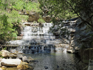
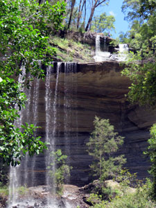
Midway down, we stopped to make a short detour and view the Ethal Falls up close, as they plunged 30m over a grey rock face in a densely vegetated grotto. Here the waters of Megalong Creek made their last drop before tumbling down Nellies Glen to the valley below. We continued on down as well, accompanied now by the babbling of the creek. The Glen now began to open up into the valley, rainforest trees were replaced by eucalyptus, light levels increased and the towering cliff line lay behind us .... we had reached the Megalong Valley.
|
|||


 Back in more open forest |
 |
 On the Six Foot Track - Megalong Valley |
The Six Foot Track now turned southwards to follow a broad gravel road along an avenue of white-trunked scribbly gums. The temperature was warming up and the walking was quick, bringing us to a cluster of horse paddocks in the middle of the forest. The distant line of orange-hued cliffs of The Narrow Neck seemed to block the way forward. Here we turned east to continue along a gravel road parallelling the cliffs for ten minutes, before a small cairn marked the start of the faint foot track that would take us to The Devils Hole (well-spotted, Lorraine, we didn't have to backtrack too far). A grouping of mossy rocks alongside the nearby small creek provided a good spot for lunch. |
||
 The cliffs of Narrow Neck |
 |
 Scrubby forest near Devils Hole Creek |
After lunch and a few jelly babies for energy, the serious part of the climb out of the valley began. The cliff-line looked down on us from on 330m above .... a slightly daunting view. Crossing the creek, we headed steadily upstream through the more open woodland, before diverting to attack the steep sub-cliff slope directly. It was calf-burning and sweaty work, but relieved by the gentler traverse of the slope into deeper shade and cooler air. We were entering the narrowing valley, where the main cliff-line and Narrow Neck converged. |
|||
 Steep approach to the cliff line |
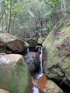
 Large boulder jammed between the rock walls |
 Heading up through the slot of Devils Hole |
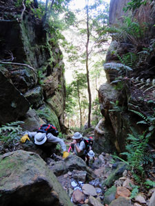 A last rock scramble to the top |
On reaching a region of large mossy slabs and boulders, the final assault began, scrambling directly up towards the narrow slot canyon ahead. Looking up, we could see an enormous boulder wedged high above the floor between the canyon walls ... welcome to The Devils Hole, the breach through the cliff-line. |
|||
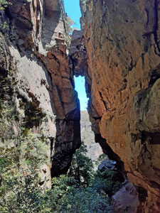 Looking back to The Devils Hole |
A final scramble brought us up beneath the boulder to the top of the slot .... it was the highlight of the walk. All that was left was one last short and gentler climb through the forest to the end of the track .... and the cars. |
 Back on the escarpment |
|
Thanks Janet for showing us this part of the Blue Mountains .... you are right, it is a memorable walk highlighting the unique micro-environments that make up this region. |
|||
|


Valley of the Waters and Wentworth Falls (9 km - 490m ascent - 490m descent) |
We woke to a light cloud cover and pleasantly cool wind. It promised to be a good walking day for our last foray in the Blue Mountains, once again a descent into the valley and a climb out. This time we would descend via the Valley of the Waters and ascend at the point where the Wentworth Falls tumbled over the cliff line ... homage to the beauty and power of mountain streams. Arriving by car at The Conservation Hut, we set out on a foot track though the dense escarpment forest ..... ooops, wrong direction. After a few hundred metres we doubled back to try again, this time finding the right route into the Valley of the Waters. Here, a well-engineered path led us downwards, solid sandstone steps and steel railings that protected from the vertical drops guiding the way. This is a route built to cater for many tourists. |
 The source of all the noise |
 The Conservation Hut |
 |
 View over the Jamison Valley from Queen Victoria Lookout |
When we reached a lookout that peered down into the depths of the Valley of the Waters, the source of its name became evident. Below us water tumbled out of a deep cleft in the rockface to create the Empress Falls. |
|
|
 The way down to the waters |
 Cascades below Empress Falls |
|

|
We followed the winding stepped track downwards into the shade of the forest to take in several different vistas of the face of the Empress Falls. Then it was onwards and steeply downwards, following the rushing stream and passing consecutive sets of falls and cascades over rockface and jumbles of mossy boulders. It was a spectacular descent passing Sylvia Falls, Lodore Falls, Flat Rock Falls, Brittania Falls and Red Rock Falls in succession as the creek tumbled down from cliff to valley floor .... each set of falls with its own unique beauty. Pictures tell it so much better ... enjoy the following. |
||
 Sylvia Falls |
 Lodore Falls |
 Britannia Falls |
|
Just below Red Rock Falls, we rock-hopped across the creek to follow the Wentworth Pass, a high traverse across the drier northern slope of the Jamison Valley. Above us, the rocks of the cliff-line loomed and around us the tall forest trees and understorey of tree-ferns, ground ferns, flowering shrubs and vines lined the path. |
|||
 Cascade through the boulders |
 Creek crossing |
 Red Rock Falls |
 The cliffs above |
|
|
|
The track led us around to the next indent in the cliff-line and the base of the Lower Wentworth Falls, lower in name only with a silvery horsetail drop of 50m into the plunge pool below. |
||


|
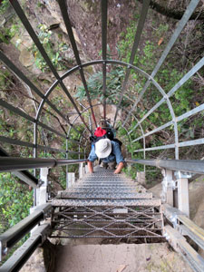
It was now time to start the climb back out of the valley. A short ascent of the rocky track brought us to Slacks Stairs, a set of several steel ladders that took us quickly up the sheer walls of the cliff face. The higher we got, the more the views opened out along the cliff face to the tree-covered valley beyond.
|
 The full 200 m drop of Wentworth Falls |
Reaching a high point we found ourselves now looking into the cleft at the full drop of Wentworth Falls, Upper and Lower, and animpressive sight. |
|
 Views to the east of the Jamison Valley ... |
 ... and to the west from the cliff-side track |
From here, a track cut into the cliffs led us around and, eventually down to the flattish platform between Upper and Lower Falls, an opportunity to look upwards and admire the silvery sparkle of the Upper Falls tumbling over the cliff edge. |
|
||
 |
 The Grand Staircase |
 |
|
There was still quite a way to climb and sheer cliffs on either side. The route out was the Grand Staircase, carved into the sandstone wall in 1908, a first in Blue Mountains tourist infrastructure, as impressive now as then. This brought us out to the sandy pool below the highest falls, a picturesque and gentle silvery shower of water. Wentworth Falls have many faces. |
|||
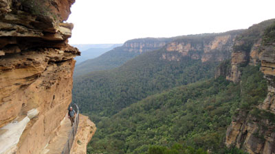
It was now time to start heading back to our start point. We followed Undercliff Track and, although it was almost on the same line as the valley traverse, it lay a few hundred metres higher, just below the top cliff line. Thus commenced a passage beneath rock overhangs and past sheer drop-offs with far-reaching panoramas of the forest-clad valley ..... this was quintessential Blue Mountains walking. |
||
 Sandy pool near the edge of the escarpment |
  |
 On the Undercliff Track On the Undercliff Track |
Crossing shady Den Fenella Creek, we climbed upwards to follow the Overcliff Track, now skirting the cliff-top forest. This brought us to one last lookout, from where we could peer directly down into the Valley of the Waters where we had started our walk. Rejoining our outward path, we quickly climbed the well-stepped track back up to The Conservation Hut and the end of a very enjoyable walk. |
|
 Two panoramas of the Jamison Valley .... |
 .... from the Overcliff Track |
The Conservation Hut was once a place where volunteers plied their trade restoring local vegetation. Now it is a cafe, and what better way to finish a walk than sitting on the deck in a cool breeze sipping an icy cold chocolate milkshake. Thus ended our brief 3-day foray into the Blue Mountains. Each walk had shown a different aspect of its landscapes .... thanks Lorraine for organising this, and thanks also to Jenny, Diana, Steve, Mark, Sally, Braham, Tim, Beat, Janet, Jacqui for your pleasant company on the walks. The feast at the Blackheath Thai Restaurant was a nice way to top off an excellent few days of bushwalking. |
|
