| Snippets of the Karhunkierros |
Getting There |
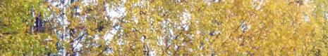
The Karhunkierros (Bear Trail) is one of Finland's best-known long distance trails, stretching over 80 km through the wilderness areas of the Oulanka National Park near the Russian border. While still being considered a being part of Lapland, it promised a very different landscape to the one we had just experienced in the north of the country. While we didn't have the time to organise a walk along its full length, we still wanted to get a feel for the landscapes through which it passed. Thus, after finishing our five-day Lapland trek, we found ourselves driving southwards from Kilpisjärvi with Gareth. He was heading back to his home in central Finland, and had offered to take us as far as Rovaniemi, where we were booked in for the night. The north of Finland is a big, sparsely-inhabited land - so there we were, driving along with few other cars to distract, as the never-ending forest gradually grew taller and changed from deciduous birch to an evergreen mixture of spruce, fir and pine. |
 |
Once in Rovaniemi, self-styled Capital of Lapland and home to Santa Claus, we said goodbye to Gareth, picked up our rental car and, the next day, drove another couple of hours in the conifer forest and past innumerable lakes to the ski resort of Ruka, not far from the Russian border in eastern Finland. Here, we settled into the small ski apartment on the shore of Lake Talvijärvi that would be our home for the next five nights, brewed up a coffee and began to plan how best to discover the secrets of this new part of Finland. |
|

Pieni Karhunkierros (12.5 km - 170m ascent - 170m descent) |


|
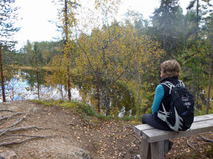
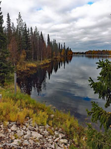
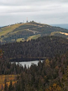
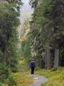
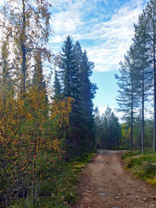
It was a beautiful autumn day, clear blue sky and sunshine, no wind and a balmy 12°C. We decided it was the sort of day to do one of Finland's iconic day-walks, the Pieni Karhunkierros (or Little Bear Trail). Unfortunately, it was a Saturday and hundreds of local Finns had made the same decision to take advantage of the fine weather. When we arrived at the trail head in the southern part of the Oulanka National Park, the car park was already almost full. Not to worry too much - the Finnish forest can soak up a lot of people and, apart from a few more "he hes" than usual as we greeted passing walkers, the large numbers were not too intrusive on the landscape. We set off from the car to quickly pick up the trail, a well-engineered track with wooden steps, boardwalk and bridges where needed. Passing the reedy fringe of Lake Ala-Juumajärvi, we entered the mixed conifer forest to cross our first suspension bridge, where a short set of rapids channelled water out of Lake Ala-Juumajärvi and into neighbouring Lake Jyrävänjärvi. |
|
Steps and boardwalk took us across the undulating forest terrain to Myllyköski, the site of an old water-mill built partly into the water at the far end of Lake Jyrävänjärvi. Here the channel narrowed dramatically to create a powerful surging set of rapids as the lake water flowed into the Kitkajoki River.
|
|

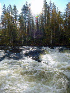


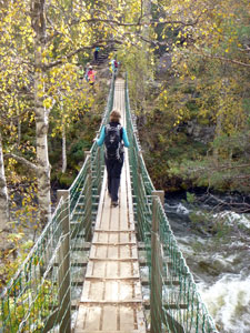
Just ahead, a queue seemed to be forming. We soon discovered it was to cross the one-person suspension bridge that bounced its way across the rapids. It was worth waiting our turn, as we got to watch a couple of rubber rafts shoot the rapids below. Once across the other side, the crowd of walkers seemed to disperse fairly quickly, merging into the Finnish forest landscape. |
||
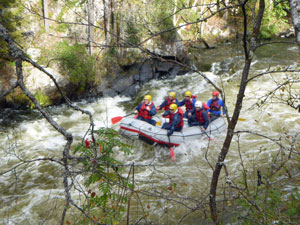 Rafters shooting the rapids |
 |
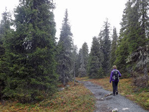
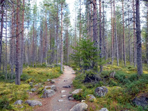 In the forest of Oulanka |
|
After crossing the bridge over another fast-flowing channel from lake to river, we soon found ourselves walking in the stillness of the conifer forest. A gentle climb brought us to the shores of Pyöreälampi, a pretty lake set in a forest hollow.
This was a tortured landscape of rocky ridges, sinkholes and hollows, softened by the lovely tarns and lakes, their mirror-like surfaces reflecting the green of conifer and autumn-gold of birch that lined their shores.
|
|


A final short steep climb brought us out to the top of the cliffs of Kallioporti, looking down on the spruce in the tight valley below. We descended to its floor via a series of 250 wooden steps, to follow a narrow, crystal-clear stream tinkling down between moss-lined banks in the cool depths of the forest. At the end of the stream lay Harrisuvanto, with its shelter, woodpile and seats, the perfect place for the Finns to prepare their steaming pots of hot lunch - we sat down and ate a sandwich. |
||
|
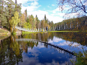
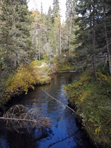
Harrisuvanto was yet another lovely body of reed-lined mirror-surfaced water, but with a long suspension bridge connecting its two shores. As we walked along the shore, we admired the perfect reflections of the conifers and scattered birches that lined its steep banks.
The track suddenly veered away from the water's edge, to make a short sharp climb up on to a drier conifer-covered ridge. We followed the ridge-line for a while and, eventually, it turned to edge its way along the Kitkajoki River. |
|


|
The sound of the river rapids drifted up from the gorge below, as we wandered along from viewpoint to viewpoint, passing picnic spots filled with Finns still enjoying their outdoor hot lunches. |
||
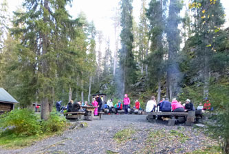 Finnish walkers having their long lunchbreak |
 Jyrävä Falls |
||
At one stage, we dropped down to river level for a close-up view of the Jyrävä Falls, thundering out of a narrow constriction in the river. Then it was a climb back up to look down the 900m length of the Aallokkoköski, a long foaming set of rapids in the river. |
|||
 |
 |
 The beauty of the Pieni Karhunkierros |
|
Finally, we arrived back at Myllyköski to complete the circuit part of the Pieni Karhunkierros. Retracing our steps for another kilometre, we arrived back at the starting point. |
|||


 |
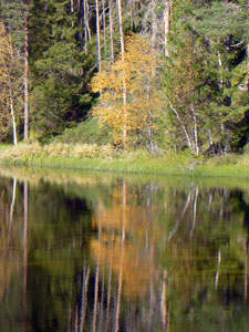
 A perfect autumn day at Lake Ala-Juumajärvi |
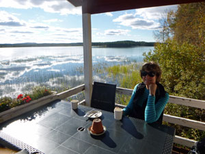 |
What a lovely trail it was in this very different part of Finland - on the shore of Lake Ala-Juumajärvi lay a small coffee shop, the perfect place to sit over a hot coffee in the warm afternoon sun and reflect on the walk just done, just as the mirror of the lake reflected the clouds above. |
||
|
Valtavaaran Huiputus (10.5 km - 410m ascent - 410m descent) |
The Finnish weather giveth and the Finnish weather taketh away - sunshine for our walk on the Pieni Karhunkierros yesterday, but back to dull grey sky for our second walk, starting at our apartment door here in Ruka. In fact, we would be in part walking the last few kilometres of the main multi-day Karhunkierros Trail. At least the temperature was a snug 14°C (which shows that I am adapting to Arctic temperatures). |
||
|
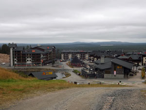
Valtavaara is the high point of a long conifer-covered ridge heading north-east away from Ruka ski resort - Huiputus translates as "swizzle". Do not ask me why this walk is called the Valtavaaran Swizzle - only a Finn could answer that. Having left our door step, we wandered down to the shore of Lake Talvijärvi to pick up the broad flat piste of a mountain-biking trail. It led us beneath the impressive 70m ski-jump platform at the station. As we approached, we heard a strange set of sounds .... a long metallic swoosh, followed by silence, then a loud slap and more swooshing. Ski-jumpers were getting a bit of out-of-season practice (and we all thought you needed snow). The fair Nello and I stopped to watch in fascination as they did so - soon divining that the silence was the period when they flew gracefully through the air before arriving with a slap on the water-slicked plastic matting of the landing slope. Great stuff! |
|

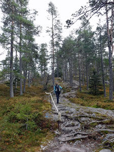
We continued along this wide track, bike-path in summer and ski-trail in winter, climbing up through the pines to where the back runs of the ski-field looked out over forest and lakes. A little later, we reached the base of the Valtavaara Ridge, where a well-signed track headed up its narrow end via a set of wooden steps and a gnarly-rooted path. We were now on the Karhunkierros Trail. |
|
|
 Mountain bike track on Ruka ski-field |
 The lake and forest landscape of Ruka |
|
Following the undulating ridge-line along, we crossed rise and hollow to reach Valtavaaranlampi, a pleasant large pond in a ridge-top hollow. A group of Finns had already arrived and, as it was well-past their 11am lunch-hour, already had the fire going to cook their sausages. Above the lake, the hut on top of Valtavaara beckoned, and we headed off for the final climb to the high point of the region.
|
||


 View back to the Ruka ski fields |
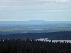
Even on a dull day, the view was impressive, stretching out over the lake-dotted forest that surrounded it and back to the grassy ski-runs of Ruka. Far to the east, the faded low hills of Russia were visible on the horizon. |
|
 Looking eastwards to the hills of Russia |
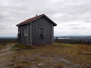 The refuge hut on Valtavaara |
|
With a bit of wind, the air on the ridge was cold, so we started the descent fairly quickly, leaving the Karhunkierros Trail to continue along the ridge. Passing a replica Lapp hut (complete with some more Finnish walkers making use of the central firepit to cook up their lunch), we found ourselves entering the taller and denser spruce and fir forest of the southern flank of Valtavaara. |
||
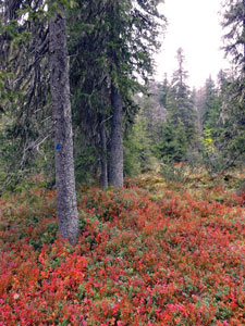 Autumn colours of the forest floor
|
The track turned west to follow a contour through this lovely forest, with its dense and red-tinted undergrowth. Boardwalks sped us over the boggy sections, until a final set of wooden steps brought us once more out to the base of Ruka's ski-runs.
For a bit of variety, we wandered up through the ski-runs of Ruka Fell, narrowly avoiding a miss-placed drive on the frisbee golf course (what doesn't one see in the ski-fields in summer). |
 Modern take on a Sami house
|
From here, a short ski-run descent led us out to the resort village, where a brief stop was needed to stock up on some supplies before the final descent alongside the 120m ski-jump to our apartment on the shore of Lake Talvijärvi. Now that jump is a monster. This walk was a long way from wilderness, but pleasant nonetheless, and, with the weather about to turn to rain and cold, it was good to have had the chance to stretch our legs in the forests of Finland before hunkering down in front of the fireplace in our apartment with hot coffees and a good book. |
|
Oulanka - Kiutaköngäs (4 km - 40m ascent - 40m descent) |
The day of rain passed, followed by a cold day with mixed cloud and occasional sunshine. We didn't want to stay indoors, but were still feeling a bit lethargic and couldn't get motivated to do a longer walk. Instead we opted to drive to the Oulanka National Park Visitors Centre, some 30 km to the north of Ruka, and check out the possibilities. |
|
The Centre lies in the northern sector of the park on the banks of the Oulanka River, which winds its way through eastern Finland, into Russia and out to the arctic waters of the White Sea. The main attraction here is Kiutaköngäs, a stretch of powerful rapids in the river and a place that the Finns have been visiting for over 100 years. |
|
 |
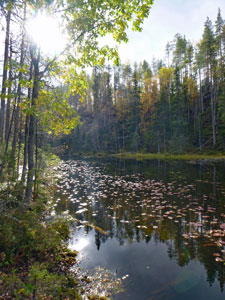
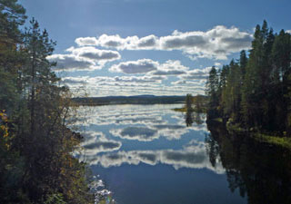
 Autumn colours on a Finnish lake |
|

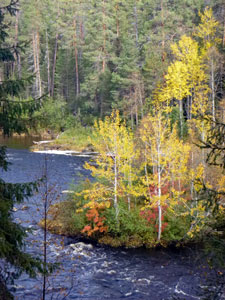
It was only a short walk, but was also one of the early sections of the Karhunkierros Trail. The well-formed track led us past a wide and still reach of the river, reflecting the surrounding conifer forest and scattered birch in their gold autumnal colours. Gradually, the current picked up speed to form a pair of small rapids either side of a rocky island. |
|
|
 The Oulanka River picking up speed ... |
 .... before entering the thundering rapids of Kiutaköngäs |
|
|
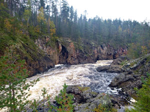
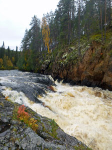
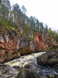
Then, a little later, the river banks converged into a narrow gorge - we had reached Kiutaköngäs. The tannin-coloured waters of the Oulanka roared and churned their way between the red-walled dolomite of the gorge walls, dropping quickly over several hundred metres to pour out into a large basin. |
|
 Red limestone walls of the Kiutaköngäs Gorge |
 The end of the rapids |
|
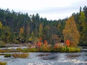
After seeing the rapids at close range, we climbed up into the forest to overlook this tranquil basin with its islets lit up by reds and yellows of the forest in autumn. It was indeed a spectacular part of the world. |
|
|
 A broad islet-studded reach of the Oulanka |
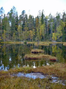
 Marshy edge of a forest pond |
|
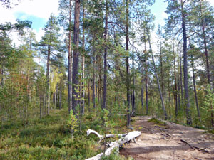
We stopped at a picnic shelter, where large numbers of Finnish walkers had settled in for lunch - it has become clear over the past few days that they love to burn wood and love to eat sausages. Both activities were well underway, as we settled in for our sandwiches. The track continued on into the conifer forest and after many a kilometre it would end up in Ruka, via the Pieni Karhunkierros, where we had walked two days ago. For us, though, it was a much quicker trip, retracing our steps back to the Visitor Centre and then driving home to Ruka. |
 The Oulanka River below the rapids |
|
 Ruka sunset |
It had certainly been worthwhile coming here to see these spectacular rapids and cliffs and, perhaps, completing our brief encounter with the landscape of north-eastern Finland. That evening, for one last time, we fired up the sauna and feted our time on the different sections of the Karhunkierros with a cold beer - Karhu, of course. |
||
|

Korouoma Gorge - where waterfalls freeze (5 km - 180m ascent - 180m descent) |
Korouoma Nature Reserve is not part of the Karhunkierros Trail. However, when I read about it at Ruka, I knew we had to go and visit this long canyon with its steep walls and many waterfalls. What's more, these falls freeze over in winter to create a world of ice-climbing challenges. Fortunately, Korouoma was on the way back to Rovaniemi. Unfortunately, we didn't have a lot of time as we had to catch the night train to Helsinki. Fortunately, in addition to the 30 km trail passing through the canyon, the Finnish park service has recently created a new hiking trail into and out of it - the Koronjää Circuit is only 5km long and takes in some of the most scenically rich parts. Now, that we could do and still get to Rovaniemi in time for the train. |
The next morning, we turned off the Rovaniemi Highway to follow a dirt road, lined with birches in their autumn splendour, for a few kilometres to reach the carpark at Saukkovaara. Putting on our day-packs, we headed off down the wide gravel track of the Koronjää Trail. It headed swiftly down into the pine and spruce forest to reach the junction of the circuit, where we decide to walk in an anti-clockwise direction. |
|
|
 The road to Korouoma |
 Start of the Koronjää Circuit |
|
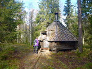
The gradual descent continued to bring us out to Kanioni, a grassy clearing on the canyon floor with huts and fireplaces next to the the dark waters of the Korojoki River. As usual, Finnish hikers had installed themselves around the fireplace, burning more wood and cooking up sausages. After making a brief detour to check out the old Lapp Hut at Piipukota, with its squared walls and central fireplace, we started to follow the river upstream. |
||
 Autumn colour at a clearing in the floor of the gorge |
 Old Sami Hut at Piipukota |
|
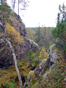
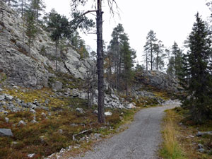
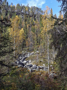
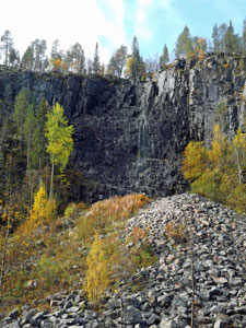
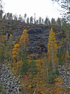
The lush canyon floor vegetation soon parted to give direct views of the canyon walls - dark rock cliffs rising above a talus of large boulders, with scatterings of spruce and gold-leafed birch. The rock jumble at the base is apparently a result of water freezing in the rock cracks on the cliff face and splitting the rock away from the wall. From the top, a trickle of water tinkled its way down the dark cliff. We had reached Ruskeavirta, the first of three waterfalls that freeze over winter. It was hard to believe that this trickle would in three months time transform into a 60m high wall of ice, reputed by climbers near and far. |
 Edging closer to the gorge walls |
 The autumn trickle of Ruskeavirta Falls |
 The Koronjää track winding up the gorge floor |
 Mammuttiputous Falls |
Continuing on, we passed two more such waterfalls, Mammuttiputous and Jaska Jokunen, both falls difficult to pick against the black rock, but both also becoming impressive ice-cliffs as the water flowing over in winter froze and gradually spread its icicles out on either side. |
|||
 Jaska Jokunen Falls in autumn .... |
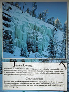 .... and how they freeze in winter |
 The Korojoki River |
 Pine-covered sand ridge in the gorge |
We continued on, crossing a curious pine-covered sand ridge in the middle of the canyon floor to cross the Korojoki River one last time at a tiny clearing where a local farmer once grazed his sheep. |
||
 Korojoki autumn |
 View from the rim of Korouoma Gorge |
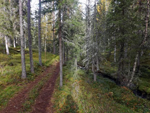 Old loggers track in the forest Old loggers track in the forest |
|
From here, a short but steep climb took us up to a view point overlooking the length of the canyon that we had walked through. It was here that I realised it is better to do this walk in the clockwise direction - taking in the grand panorama of the canyon to get a better feel for the landscape that you will later walk through and, importantly, ending up at Kanioni for wood-fired sausages at lunchtime. From the lookout, the track followed an old loggers' trail through the gently undulating pine and spruce forest. Here, we walked on the track where horse-drawn sleds once hauled logs down to the river to be floated away to the downstream mills - a nice touch of history and a pleasant setting, where a tranquil stream babbled its way down between dense mossy banks, before picking up speed to drop off over 5m waterfall beneath the pines. I suspect that this tiny fall carried more water than any of the 60m high falls trickling over the canyon wall. |
|


We had now completed the circuit and retraced our steps back up the hill to the car park. We enjoyed the Koronjää Trail and the Korouoma Gorge was definitely worth the detour. However, one day we must come back in winter - to see a series of 60m high and 20-60m wide frozen waterfalls. Now that would really be something. |
|